IMAGES TAKEN NEAR TO
Clifton Marine Parade, GRAVESEND, DA11 0DH
Introduction
This page details the photographs taken nearby to Clifton Marine Parade, DA11 0DH by members of the Geograph project.
The Geograph project started in 2005 with the aim of publishing, organising and preserving representative images for every square kilometre of Great Britain, Ireland and the Isle of Man.

There are currently over 7.5m images from over14,400 individuals and you can help contribute to the project by visiting https://www.geograph.org.uk
Image Map
Images are licensed for reuse under creativecommons.org/licenses/by-sa/2.0
Notes
- Clicking on the map will re-center to the selected point.
- The higher the marker number, the further away the image location is from the centre of the postcode.
Image Listing (114 Images Found)
Images are licensed for reuse under creativecommons.org/licenses/by-sa/2.0
Image
Details
Distance
1
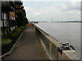
Looking west along a riverside walk
From beside Baltic Wharf apartments, which overlook the River Thames.
Image: © John Baker
Taken: 21 Jul 2016
0.01 miles
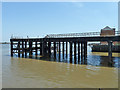
2
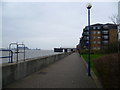
Riverside walkway, Gravesend
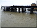
This is the riverside walkway between Clifton Marine Parade and Baltic Wharf. In this photograph the development of Baltic Wharf is on the right, whilst Tilbury Power Station is across the Thames to the left. The pier is the old West Street Pier - see http://www.geograph.org.uk/photo/2883374 Unfortunately the other end of the walkway at Clifton Marine Parade is not quite what was envisaged by its builders - see http://www.geograph.org.uk/photo/2885675
Image: © Marathon
Taken: 5 Apr 2012
0.02 miles
3
Fletcher's Wharf
Formerly fronting the Imperial Paper Mills site, this in now redeveloped with flats and, mainly, retail parks.
Image: © Robin Webster
Taken: 27 Jun 2011
0.03 miles
4
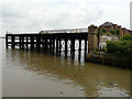
Remains of Gravesend West Station?s pier
The branch railway from Farningham Road was opened on 10 May 1886, closed to passengers on 3 August 1953 and closed completely on 25 August 1968. The majority of the station was demolished in 1991 but the pier with its covered way, West Street bridge and a short section of platform survived until September 2006, when the remaining section of viaduct and the bridge over West Street were demolished
http://www.disused-stations.org.uk/g/gravesend_west_street/index.shtml This view was taken from the top of a wall at Baltic Wharf.
Image: © John Baker
Taken: 21 Jul 2016
0.06 miles
5
Old railway pier, Gravesend
The end of the London, Chatham and Dover Railway's branch to attempt to get a share of the Gravesend market from the South Eastern Railway. The two companies were to merge, and this line was rather pointless for passengers thereafter, but remained partly open for freight until 1968.
Image: © Robin Webster
Taken: 27 Jun 2011
0.06 miles
6
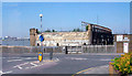
Gravesend West Street railway station (site), Kent
Opened in 1886 by the Gravesend Railway as the terminus of its line from Longfield, this station closed to passengers in 1953 and completely in 1968.
View north west from Stuart Road. There was a long platform and covered walkway stretching round onto the pier, visible to the right. To the left was a small goods yard. The main building was roughly where the trees on the extreme left now are.
Image: © Nigel Thompson
Taken: 20 Feb 2010
0.06 miles
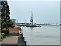
7
Gravesend West Street Pier, view seaward, 1995
View NE from near site of Gravesend West Street station - off to right: terminus of ex-SE&CR branch from Farningham Road, closed to passengers 3/8/53, to goods 28/3/68. Across the Thames Estuary is Tilbury Power Station.
Image: © Ben Brooksbank
Taken: 11 Mar 1995
0.06 miles
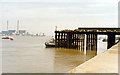
9
West Street Pier, Gravesend
The Gravesend West Line branched off the Swanley to Chatham line at Fawkham Junction and continued to Gravesend where the railway company constructed a pier to connect trains with steamers. The line opened in 1886 and closed to passenger services in 1953, remaining open to freight until 1968. The majority of Gravesend West station was demolished in 1991, with the remaining section of viaduct and bridge over West Street going in September 2006. This left the pier in glorious isolation. It is here viewed from the riverside walkway by Baltic Wharf. For more information on the Gravesend West Line see http://en.wikipedia.org/wiki/Gravesend_West_Line and http://www.disused-stations.org.uk/g/gravesend_west_street/index.shtml The car park for Wickes in Stuart Road is now on the site of Gravesend West station.
Image: © Marathon
Taken: 5 Apr 2012
0.07 miles
10
Gravesend: remains of West Street Pier
View NE, across the Thames Estuary to Tilbury; site of former Gravesend West Street station. (Cf. Image], also Image).
Image: © Ben Brooksbank
Taken: 8 May 2008
0.07 miles