IMAGES TAKEN NEAR TO
Blandford Drive, NORTHWICH, CW9 8UD
Introduction
This page details the photographs taken nearby to Blandford Drive, CW9 8UD by members of the Geograph project.
The Geograph project started in 2005 with the aim of publishing, organising and preserving representative images for every square kilometre of Great Britain, Ireland and the Isle of Man.

There are currently over 7.5m images from over14,400 individuals and you can help contribute to the project by visiting https://www.geograph.org.uk
Image Map
Images are licensed for reuse under creativecommons.org/licenses/by-sa/2.0
Notes
- Clicking on the map will re-center to the selected point.
- The higher the marker number, the further away the image location is from the centre of the postcode.
Image Listing (7 Images Found)
Images are licensed for reuse under creativecommons.org/licenses/by-sa/2.0
Image
Details
Distance
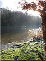
1
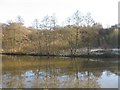
River Weaver
A peaceful winter scene, the East bank of the River Weaver seen from the watermeadows.
Image: © Dr Duncan Pepper
Taken: 7 Dec 2008
0.16 miles
2
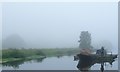
Strange encounter on the Weaver Navigation
CRT workboat Hercules heading upstream with two pontoons on a misty morning.
Image: © Christine Johnstone
Taken: 15 Sep 2016
0.17 miles
3
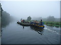
Hercules working on the Weaver Navigation
CRT [ex British Waterways] workboat, being used to move two pontoons south from Northwich.
Image: © Christine Johnstone
Taken: 15 Sep 2016
0.17 miles
4
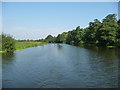
Weaver Navigation at Poor's Wood
Looking downstream [locally north-east].
Image: © Christine Johnstone
Taken: 14 Sep 2016
0.19 miles
6
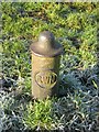
Cast Iron Boundary Post beside the River Weaver
A nice little elegant boundary post erected by the River Weaver Navigation when this river was turned into a navigable waterway for the transport of salt.
Image: © Dr Duncan Pepper
Taken: 7 Dec 2008
0.20 miles
7
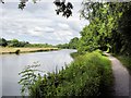
River Weaver near Poor's Wood
Davenham - footpath 2 beside the River Weaver near Poor's Wood. View downstream.
Image: © Mike Harris
Taken: 15 Jun 2008
0.21 miles