IMAGES TAKEN NEAR TO
Davenham Road, NORTHWICH, CW9 7RZ
Introduction
This page details the photographs taken nearby to Davenham Road, CW9 7RZ by members of the Geograph project.
The Geograph project started in 2005 with the aim of publishing, organising and preserving representative images for every square kilometre of Great Britain, Ireland and the Isle of Man.

There are currently over 7.5m images from over14,400 individuals and you can help contribute to the project by visiting https://www.geograph.org.uk
Image Map
Images are licensed for reuse under creativecommons.org/licenses/by-sa/2.0
Notes
- Clicking on the map will re-center to the selected point.
- The higher the marker number, the further away the image location is from the centre of the postcode.
Image Listing (16 Images Found)
Images are licensed for reuse under creativecommons.org/licenses/by-sa/2.0
Image
Details
Distance
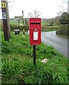
1
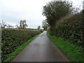
Shurlach Lane, Shipbrookhill
Showing position of Postbox No. CW9 124.
See Image] for context.
Image: © JThomas
Taken: 21 Mar 2024
0.18 miles
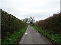
3
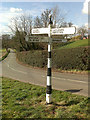
Signpost near Shipbrook Hill Farm
Giving the impression that this was once an important crossroads.
Image: © David Lally
Taken: 9 Mar 2009
0.18 miles
4
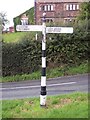
Old Direction Sign - Signpost by Manor Lane, Northwich parish
Pawn finial - 4 arms; Cheshire CCC octagonal in parish of Northwich (Vale Royal District), Shipbrook Road junction with Manor Lane, Shipbrookhill.
To be surveyed
Milestone Society National ID: CH_SJ6771
Image: © Milestone Society
Taken: Unknown
0.18 miles
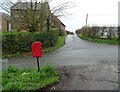
6
Elizabeth II postbox, Shipbrookhill
Postbox No. CW9 124.
See Image] for context.
Image: © JThomas
Taken: 21 Mar 2024
0.18 miles
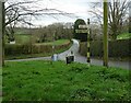
8
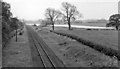
Near site of Billinge Green Halt
View southwards, towards Middlewich and Sandbach; Sandbach - Middlewich - Northwich line. Actually, the Halt was behind the camera: it closed 2/5/42, passenger services on the line ceased 4/1/60, but the line is still open for through freight traffic. The lake in the view is probably one of those formed near the Trent & Mersey Canal, as a result of the extensive extraction of salt deposits in the district.
Image: © Ben Brooksbank
Taken: 22 May 1961
0.18 miles