IMAGES TAKEN NEAR TO
Arthur Street, NORTHWICH, CW9 7PR
Introduction
This page details the photographs taken nearby to Arthur Street, CW9 7PR by members of the Geograph project.
The Geograph project started in 2005 with the aim of publishing, organising and preserving representative images for every square kilometre of Great Britain, Ireland and the Isle of Man.

There are currently over 7.5m images from over14,400 individuals and you can help contribute to the project by visiting https://www.geograph.org.uk
Image Map
Images are licensed for reuse under creativecommons.org/licenses/by-sa/2.0
Notes
- Clicking on the map will re-center to the selected point.
- The higher the marker number, the further away the image location is from the centre of the postcode.
Image Listing (48 Images Found)
Images are licensed for reuse under creativecommons.org/licenses/by-sa/2.0
Image
Details
Distance
1
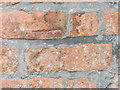
OS Cut Mark
Cut mark on St John's church tower, Lostock Gralam
Image: © Chris Cursley
Taken: 14 Sep 2016
0.03 miles
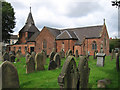
2
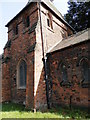
St John's Church Tower, Lostock Gralam
View of tower from the southeast
Image: © Chris Cursley
Taken: 14 Sep 2016
0.03 miles
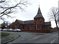
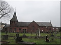
5
Lostock Gralam - Church
For an alternative view, please see Image
Image: © Dave Bevis
Taken: 29 Aug 2013
0.03 miles
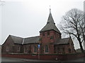
7
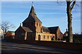
St John the Evangelist Church, Lostock Gralam
Image: © Ian S
Taken: 30 Jan 2022
0.03 miles
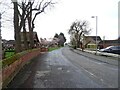
10
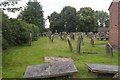
Churchyard, Lostock Gralham
Between the church and primary school.
Image: © Richard Webb
Taken: 16 Jul 2019
0.05 miles