IMAGES TAKEN NEAR TO
Wardle Drive, NORTHWICH, CW9 7LW
Introduction
This page details the photographs taken nearby to Wardle Drive, CW9 7LW by members of the Geograph project.
The Geograph project started in 2005 with the aim of publishing, organising and preserving representative images for every square kilometre of Great Britain, Ireland and the Isle of Man.

There are currently over 7.5m images from over14,400 individuals and you can help contribute to the project by visiting https://www.geograph.org.uk
Image Map
Images are licensed for reuse under creativecommons.org/licenses/by-sa/2.0
Notes
- Clicking on the map will re-center to the selected point.
- The higher the marker number, the further away the image location is from the centre of the postcode.
Image Listing (15 Images Found)
Images are licensed for reuse under creativecommons.org/licenses/by-sa/2.0
Image
Details
Distance
2
Shipbrook Road and the Gad Brook valley
Shipbrook Road and the Gad Brook valley, Northwich.
Image: © Mike Harris
Taken: 7 May 2007
0.04 miles
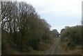
4
Railway heading South from Northwich
"Next station stop-Sandbach"
Image: © Dr Duncan Pepper
Taken: 17 Nov 2011
0.07 miles
5
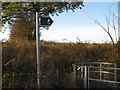
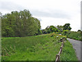
Stile and footpath into the Dane valley (2)
Image: © Dr Duncan Pepper
Taken: 17 Nov 2011
0.07 miles
6
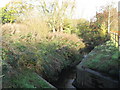
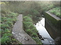
The Gad Brook looking downstream and before it joins the River Dane
Image: © Dr Duncan Pepper
Taken: 17 Nov 2011
0.07 miles
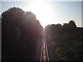
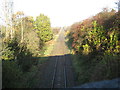
7
Railway towards Sandbach
Looking south east from the bridge on Shipbrook Road.
Image: © JThomas
Taken: 21 Mar 2024
0.08 miles
8
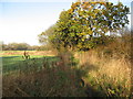
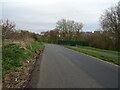
Footpath heading North into the Dane Valley
Image: © Dr Duncan Pepper
Taken: 17 Nov 2011
0.10 miles
9
Railway heading North into Northwich
Image: © Dr Duncan Pepper
Taken: 17 Nov 2011
0.20 miles
