IMAGES TAKEN NEAR TO
Ashbank, NORTHWICH, CW9 7HZ
Introduction
This page details the photographs taken nearby to Ashbank, CW9 7HZ by members of the Geograph project.
The Geograph project started in 2005 with the aim of publishing, organising and preserving representative images for every square kilometre of Great Britain, Ireland and the Isle of Man.

There are currently over 7.5m images from over14,400 individuals and you can help contribute to the project by visiting https://www.geograph.org.uk
Image Map
Images are licensed for reuse under creativecommons.org/licenses/by-sa/2.0
Notes
- Clicking on the map will re-center to the selected point.
- The higher the marker number, the further away the image location is from the centre of the postcode.
Image Listing (7 Images Found)
Images are licensed for reuse under creativecommons.org/licenses/by-sa/2.0
Image
Details
Distance
1
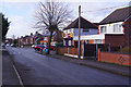
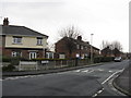
West Avenue, Rudheath
Whoever designated the street names in this area seems to have lacked imagination - as well as West Avenue there is East Avenue, South Drive, North Drive and Central Road. In this view G K Stores, a convenience shop, is on the right.
Image: © Stephen McKay
Taken: 5 Mar 2019
0.15 miles
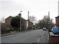
3
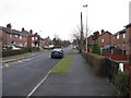
Gadbrook Road, Northwich
Prominent date on house.(1932)
Image: © Richard Webb
Taken: 30 Jun 2018
0.17 miles
7
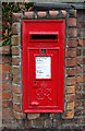
George VI postbox on Shipbrook Road, Rudheath
Postbox No. CW9 46.
Image: © JThomas
Taken: 21 Mar 2024
0.24 miles