IMAGES TAKEN NEAR TO
Crows Nest Lane, NORTHWICH, CW9 6HZ
Introduction
This page details the photographs taken nearby to Crows Nest Lane, CW9 6HZ by members of the Geograph project.
The Geograph project started in 2005 with the aim of publishing, organising and preserving representative images for every square kilometre of Great Britain, Ireland and the Isle of Man.

There are currently over 7.5m images from over14,400 individuals and you can help contribute to the project by visiting https://www.geograph.org.uk
Image Map
Images are licensed for reuse under creativecommons.org/licenses/by-sa/2.0
Notes
- Clicking on the map will re-center to the selected point.
- The higher the marker number, the further away the image location is from the centre of the postcode.
Image Listing (6 Images Found)
Images are licensed for reuse under creativecommons.org/licenses/by-sa/2.0
Image
Details
Distance
1
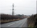
Gibb Hill
The lane slopes more steeply than is obvious down to Comberbach.
Image: © Peter Whatley
Taken: 19 Jan 2010
0.11 miles
2
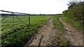
Field entrance, Gibb Hill
The soils here are sandy.
Image: © Richard Webb
Taken: 5 Apr 2012
0.17 miles
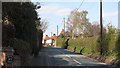
4
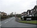
The Avenue, Comberbatch
This road has found a role as the barrier to housing development in a massively expanded village. Across the road are fields, on this side residential streets.
Image: © Richard Webb
Taken: 5 Apr 2012
0.21 miles
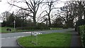
6
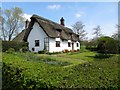
Cottage in Comberbach
The perfect chocolate box cottage.
Image: © philandju
Taken: 20 Apr 2015
0.25 miles