IMAGES TAKEN NEAR TO
Marston Lane, NORTHWICH, CW9 6DH
Introduction
This page details the photographs taken nearby to Marston Lane, CW9 6DH by members of the Geograph project.
The Geograph project started in 2005 with the aim of publishing, organising and preserving representative images for every square kilometre of Great Britain, Ireland and the Isle of Man.

There are currently over 7.5m images from over14,400 individuals and you can help contribute to the project by visiting https://www.geograph.org.uk
Image Map
Images are licensed for reuse under creativecommons.org/licenses/by-sa/2.0
Notes
- Clicking on the map will re-center to the selected point.
- The higher the marker number, the further away the image location is from the centre of the postcode.
Image Listing (8 Images Found)
Images are licensed for reuse under creativecommons.org/licenses/by-sa/2.0
Image
Details
Distance
2
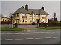
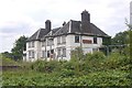
The Black Greyhound, Higher Wincham
Situated at the crossroads of Hall Lane, Marston Lane, Wincham Lane & Church Street.
Image: © Ian Warburton
Taken: 4 Dec 2005
0.13 miles
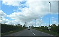
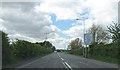
3
Approaching the junction
Of the B5391 and the A559.
Image: © John H Darch
Taken: 5 Jul 2020
0.15 miles
4
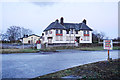
The Black Greyhound
Currently looking forlornly neglected. It is a site which depends on drivers for its trade.
Image: © Bill Boaden
Taken: 21 Feb 2015
0.16 miles
5
The Black Greyhound
A pub building rapidly deteriorating after closure. (2005 image when open: Image)
Image: © Richard Webb
Taken: 16 Jul 2019
0.16 miles
6
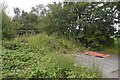
Entrance to the Black Greyhound car park
Brambles quickly colonised the surroundings of an abandoned pub ruin.
Image: © Richard Webb
Taken: 16 Jul 2019
0.18 miles
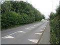
7
The A559 near the Black Greyhound junction
Image: © Anthony Parkes
Taken: 22 May 2013
0.18 miles
8
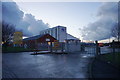
New Cheshire Business Park at dusk
One of the several business areas around Wincham.
Image: © Bill Boaden
Taken: 21 Feb 2015
0.24 miles