IMAGES TAKEN NEAR TO
Clatterwick Lane, NORTHWICH, CW8 4RJ
Introduction
This page details the photographs taken nearby to Clatterwick Lane, CW8 4RJ by members of the Geograph project.
The Geograph project started in 2005 with the aim of publishing, organising and preserving representative images for every square kilometre of Great Britain, Ireland and the Isle of Man.

There are currently over 7.5m images from over14,400 individuals and you can help contribute to the project by visiting https://www.geograph.org.uk
Image Map
Images are licensed for reuse under creativecommons.org/licenses/by-sa/2.0
Notes
- Clicking on the map will re-center to the selected point.
- The higher the marker number, the further away the image location is from the centre of the postcode.
Image Listing (5 Images Found)
Images are licensed for reuse under creativecommons.org/licenses/by-sa/2.0
Image
Details
Distance
1
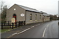
The Baptist Church, Little Leigh
The date plate says 1829.
Image: © David Long
Taken: 7 Jan 2009
0.21 miles
4
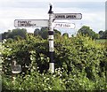
Direction Sign - Signpost in Crumleyheath
Pawn finial - 3 arms; Cheshire New CCC octagonal by the UC road, in parish of Comberbach (Vale Royal District), Cogshall Lane junction with Sutley Lane, Crumleyheath.
To be surveyed
Milestone Society National ID: CH_SJ6276
Image: © Milestone Society
Taken: Unknown
0.23 miles
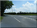
5
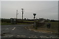
Northern end of Shutley Lane, opposite Crumleyheath Farm
Image: © David Long
Taken: 7 Jan 2009
0.25 miles