IMAGES TAKEN NEAR TO
Rosebank Walk, NORTHWICH, CW8 4PU
Introduction
This page details the photographs taken nearby to Rosebank Walk, CW8 4PU by members of the Geograph project.
The Geograph project started in 2005 with the aim of publishing, organising and preserving representative images for every square kilometre of Great Britain, Ireland and the Isle of Man.

There are currently over 7.5m images from over14,400 individuals and you can help contribute to the project by visiting https://www.geograph.org.uk
Image Map
Images are licensed for reuse under creativecommons.org/licenses/by-sa/2.0
Notes
- Clicking on the map will re-center to the selected point.
- The higher the marker number, the further away the image location is from the centre of the postcode.
Image Listing (16 Images Found)
Images are licensed for reuse under creativecommons.org/licenses/by-sa/2.0
Image
Details
Distance
1
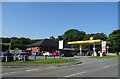
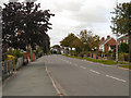
Service station on Runcorn Road (A533), Barnton
Petrol 136.9p.
Diesel 140.9p.
Image: © JThomas
Taken: 6 Sep 2024
0.14 miles
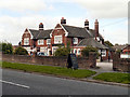
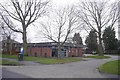
3
The closed Beech Tree public house
Located along the A533 Runcorn Road in the village of Barnton.
Image
Image: © Mat Fascione
Taken: 15 Jul 2015
0.17 miles
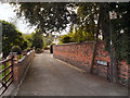

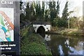
8
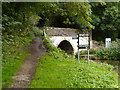
Trent and Mersey Canal, Saltersford Tunnel
The eastern end of Saltersford Tunnel on the Trent and Mersey Canal.
Image: © David Dixon
Taken: 5 Sep 2012
0.24 miles
9
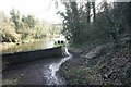
Overland route at Saltersford Tunnel, Trent & Mersey Canal
Image: © Ian S
Taken: 29 Jan 2022
0.24 miles
10
Trent & Mersey Canal at bridge #203, Saltersford Tunnel
Image: © Ian S
Taken: 29 Jan 2022
0.24 miles