IMAGES TAKEN NEAR TO
Princes Park, NORTHWICH, CW8 4HB
Introduction
This page details the photographs taken nearby to Princes Park, CW8 4HB by members of the Geograph project.
The Geograph project started in 2005 with the aim of publishing, organising and preserving representative images for every square kilometre of Great Britain, Ireland and the Isle of Man.

There are currently over 7.5m images from over14,400 individuals and you can help contribute to the project by visiting https://www.geograph.org.uk
Image Map
Images are licensed for reuse under creativecommons.org/licenses/by-sa/2.0
Notes
- Clicking on the map will re-center to the selected point.
- The higher the marker number, the further away the image location is from the centre of the postcode.
Image Listing (71 Images Found)
Images are licensed for reuse under creativecommons.org/licenses/by-sa/2.0
Image
Details
Distance
2
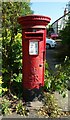
Elizabeth II postbox on Runcorn Road, Barnton
Postbox No. CW8 1.
Image: © JThomas
Taken: 6 Sep 2024
0.05 miles
3
Barnton Pharmacy and Post Office
Dual purpose shop at the corner of Lydyett Lane and Runcorn Road.
Image: © David Dixon
Taken: 5 Sep 2012
0.05 miles
5
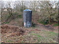
Air Shaft Servicing Barnton Tunnel
On the Trent and Mersey Canal
Image: © Gary Rogers
Taken: 20 Mar 2019
0.09 miles
6
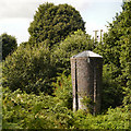
Barnton Tunnel Ventilation Shaft
One of the ventilation towers on the line of the Barnton canal tunnel.
Image: © David Dixon
Taken: 5 Sep 2012
0.09 miles
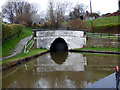
7

In Barnton Tunnel, 1990
Heading east, showing the lack of straightness in the tunnel. This is towards the eastern end, probably east of the eastern air shaft, one of two. It is certainly after I had photographed one of the air shafts! This tunnel was in the final length of the Trent and Mersey Canal to be opened, in 1777. This length, from Acton to Middlewich, approached very closely the steep bank above the Weaver, which caused some concern, and it would appear Barnton and Saltersford Tunnels were afterthoughts to avoid a potentially unstable route.
Image: © Robin Webster
Taken: 25 Sep 1990
0.10 miles
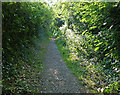
9
Overland route, Barton Tunnel, Trent & Mersey Canal
Image: © Ian S
Taken: 29 Jan 2022
0.12 miles
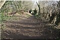
10
Trent and Mersey Canal: Barnton Tunnel, East Portal
Barnton Tunnel is not wide enough for boats to pass inside, so skippers must be certain that a boat is not coming the other way before they enter. Give a long blast on the horn to make quite sure.
Image: © Dr Neil Clifton
Taken: 3 Apr 2015
0.12 miles