IMAGES TAKEN NEAR TO
Hollybank Close, NORTHWICH, CW8 4GS
Introduction
This page details the photographs taken nearby to Hollybank Close, CW8 4GS by members of the Geograph project.
The Geograph project started in 2005 with the aim of publishing, organising and preserving representative images for every square kilometre of Great Britain, Ireland and the Isle of Man.

There are currently over 7.5m images from over14,400 individuals and you can help contribute to the project by visiting https://www.geograph.org.uk
Image Map (Loading...)


Getting Data...Please wait
Leaflet Map data © OpenStreetMap
Images are licensed for reuse under creativecommons.org/licenses/by-sa/2.0
Notes
- Clicking on the map will re-center to the selected point.
- The higher the marker number, the further away the image location is from the centre of the postcode.
Image Listing (21 Images Found)
Images are licensed for reuse under creativecommons.org/licenses/by-sa/2.0
Image
Details
Distance
1
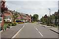
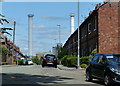
Modern housing at Winnington
Hollybank Close, the modern version of the terraced housing in the adjacent Solvay Road Image
Image: © Alan Murray-Rust
Taken: 15 May 2008
0.02 miles
2
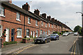
Solvay Road, Winnington
Terraced housing built for workers at the Winnington chemical works; the houses have a pleasing uniform style
Image: © Alan Murray-Rust
Taken: 15 May 2008
0.05 miles
3
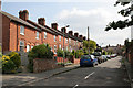
Hemming Street, Winnington
These houses are to a slightly different design to the ones in the next street Image and enjoy the benefit of front gardens.
Image: © Alan Murray-Rust
Taken: 15 May 2008
0.09 miles
4
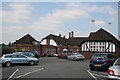
Winnington Park Recreation Club
This would originally have been the Brunner Mond sports club and incorporates a pavilion as well as a variety of indoor social activities. The building has date stones of 1937 (above the triangular porch) and 1923 (on the flat-roofed building immediately to the left). The front of the building appears in Image
Image: © Alan Murray-Rust
Taken: 15 May 2008
0.11 miles
6
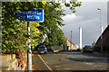
Solvay Road, Winnington
Seen from Winnington Lane with a backdrop of chimneys belonging to Winnington Works.
Image: © Stephen McKay
Taken: 13 Sep 2017
0.13 miles
7
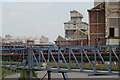
Brunner Mond Winnington
View from the Winnington Lane bridge over the railway to the Wallerscote Island site. The distant tall building is the lime kilns.
Image: © Alan Murray-Rust
Taken: 15 May 2008
0.15 miles
8
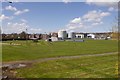
Cricket ground, Northwich
Off Park Road.
Image: © Richard Webb
Taken: 17 Apr 2016
0.16 miles
9
Winnington Park Recreation Club
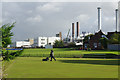
The bowling green is being mowed in the morning with a backdrop of Winnington Works.
Image: © Stephen McKay
Taken: 13 Sep 2017
0.17 miles
10
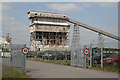
Brunner Mond, Winnington - lime kilns
Salt and limestone are the basic building blocks of the chemical industry in the area.
Lime is burnt to create quicklime which is then slaked to become calcium hydroxide. This can be combined with sodium carbonate (washing soda)- itself a result of combining salt and limestone - to produce caustic soda; the growth of the salt industry was driven by the use of these two chemicals in the burgeoning soap and cleansing agents industry at the end of the 19th century. Finding uses for the excess Chlorine was one of the driving forces behind the original Brunner Mond company, later ICI, developing uses in the pharmaceutical and plastics fields. This site is where polythene was first developed.
Image: © Alan Murray-Rust
Taken: 15 May 2008
0.19 miles