IMAGES TAKEN NEAR TO
Winnington Avenue, NORTHWICH, CW8 4FT
Introduction
This page details the photographs taken nearby to Winnington Avenue, CW8 4FT by members of the Geograph project.
The Geograph project started in 2005 with the aim of publishing, organising and preserving representative images for every square kilometre of Great Britain, Ireland and the Isle of Man.

There are currently over 7.5m images from over14,400 individuals and you can help contribute to the project by visiting https://www.geograph.org.uk
Image Map
Images are licensed for reuse under creativecommons.org/licenses/by-sa/2.0
Notes
- Clicking on the map will re-center to the selected point.
- The higher the marker number, the further away the image location is from the centre of the postcode.
Image Listing (12 Images Found)
Images are licensed for reuse under creativecommons.org/licenses/by-sa/2.0
Image
Details
Distance
4
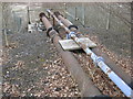
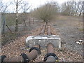
End of the line
Discharge point from pipeline into former brine lagoon.
Image: © Dr Duncan Pepper
Taken: 27 Mar 2010
0.12 miles
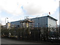
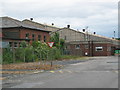
8
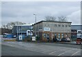
Works, close to Moss Farm, Northwich
Area of mixed industry this building is at 643737
Image: © Lizzie
Taken: 12 Jun 2005
0.21 miles
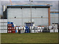
9
Works close to Moss Farm
An area of mixed industry.
Image: © Lizzie
Taken: 12 Jun 2005
0.21 miles
10
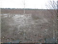
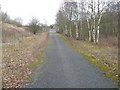
Death Valley-former salt lagoon with struggling saplings
Image: © Dr Duncan Pepper
Taken: 27 Mar 2010
0.23 miles