IMAGES TAKEN NEAR TO
Runcorn Road, NORTHWICH, CW8 4ER
Introduction
This page details the photographs taken nearby to Runcorn Road, CW8 4ER by members of the Geograph project.
The Geograph project started in 2005 with the aim of publishing, organising and preserving representative images for every square kilometre of Great Britain, Ireland and the Isle of Man.

There are currently over 7.5m images from over14,400 individuals and you can help contribute to the project by visiting https://www.geograph.org.uk
Image Map
Images are licensed for reuse under creativecommons.org/licenses/by-sa/2.0
Notes
- Clicking on the map will re-center to the selected point.
- The higher the marker number, the further away the image location is from the centre of the postcode.
Image Listing (81 Images Found)
Images are licensed for reuse under creativecommons.org/licenses/by-sa/2.0
Image
Details
Distance
1
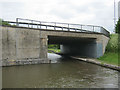
Bridge 201
Trent and Mersey Canal, near Barnton Tunnel, taken from west side
Image: © Mike Todd
Taken: 16 May 2011
0.05 miles
2
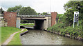
Bridge 201 East side
Trent and Mersey Canal, near Barnton Tunnel, taken from east side
Image: © Mike Todd
Taken: 16 May 2011
0.05 miles
3
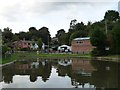
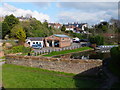
Canalside business, Barnton
On the north bank of the Trent & Mersey Canal, at the east end of Barnton Tunnel.
Image: © Christine Johnstone
Taken: 22 Sep 2016
0.05 miles
4

Christ Church, Barnton
Christ Church (parish church) on Church Road, Barnton.
Image: © Mike Harris
Taken: 19 Jul 2006
0.05 miles
7
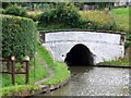
Eastern Portal of Barnton Tunnel, Trent and Mersey Canal
Image: © David Martin
Taken: 6 Aug 2010
0.06 miles
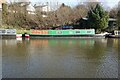
9
Barnton Canal Basin, Trent and Mersey Canal
Image: © David Dixon
Taken: 5 Sep 2012
0.06 miles
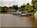
10

Trent & Mersey Canal and towpath at Barnton
Image: © Colin Park
Taken: 30 Apr 2000
0.07 miles