IMAGES TAKEN NEAR TO
The Woodlands, Winnington Lane, NORTHWICH, CW8 4EA
Introduction
This page details the photographs taken nearby to The Woodlands, Winnington Lane, CW8 4EA by members of the Geograph project.
The Geograph project started in 2005 with the aim of publishing, organising and preserving representative images for every square kilometre of Great Britain, Ireland and the Isle of Man.

There are currently over 7.5m images from over14,400 individuals and you can help contribute to the project by visiting https://www.geograph.org.uk
Image Map
Images are licensed for reuse under creativecommons.org/licenses/by-sa/2.0
Notes
- Clicking on the map will re-center to the selected point.
- The higher the marker number, the further away the image location is from the centre of the postcode.
Image Listing (7 Images Found)
Images are licensed for reuse under creativecommons.org/licenses/by-sa/2.0
Image
Details
Distance
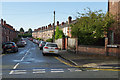
1
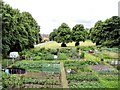
Allotment gardens and recreation area beside Birdcage Walk
Northwich - allotment gardens and recreation area beside Birdcage Walk. Seen from the footbridge over the railway on Northwich footpath 12.
Image: © Mike Harris
Taken: 15 Jun 2008
0.10 miles
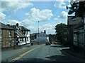
5
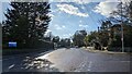
Winnington - Northwich footpath 12
Northwich (Winnington) - view along Northwich footpath 12 from the corner of Appleton Street (derelict nr 22 is on the left). The footpath leads into a small recreation ground before crossing the railway to Verdin Park.
Image: © Mike Harris
Taken: 15 Jun 2008
0.20 miles
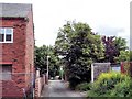
7
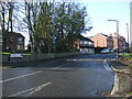
Moreton Street, Winnington
Street of terraced houses leading off Winnington Lane.
Image: © Stephen McKay
Taken: 13 Sep 2017
0.23 miles