IMAGES TAKEN NEAR TO
Huntersfield, NORTHWICH, CW8 4AT
Introduction
This page details the photographs taken nearby to Huntersfield, CW8 4AT by members of the Geograph project.
The Geograph project started in 2005 with the aim of publishing, organising and preserving representative images for every square kilometre of Great Britain, Ireland and the Isle of Man.

There are currently over 7.5m images from over14,400 individuals and you can help contribute to the project by visiting https://www.geograph.org.uk
Image Map
Images are licensed for reuse under creativecommons.org/licenses/by-sa/2.0
Notes
- Clicking on the map will re-center to the selected point.
- The higher the marker number, the further away the image location is from the centre of the postcode.
Image Listing (19 Images Found)
Images are licensed for reuse under creativecommons.org/licenses/by-sa/2.0
Image
Details
Distance
2
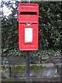
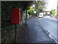
Elizabeth II postbox on Chester Road, Northwich
Postbox No. CW8 26.
See Image] for context.
Image: © JThomas
Taken: 20 Mar 2024
0.10 miles
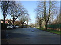
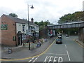
3
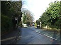
Chester Road, Northwich
Showing position of Postbox No. CW8 26.
See Image] for postbox.
Image: © JThomas
Taken: 20 Mar 2024
0.10 miles
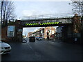
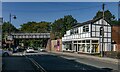
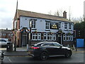
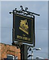
7
The Iron Bridge pub on Chester Road
Image: © Raymond Knapman
Taken: 26 Sep 2013
0.16 miles
10
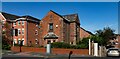
Chester Road
House on Chester Road.
Image: © Peter McDermott
Taken: 24 Aug 2019
0.19 miles