IMAGES TAKEN NEAR TO
Hill Top Road, NORTHWICH, CW8 3RA
Introduction
This page details the photographs taken nearby to Hill Top Road, CW8 3RA by members of the Geograph project.
The Geograph project started in 2005 with the aim of publishing, organising and preserving representative images for every square kilometre of Great Britain, Ireland and the Isle of Man.

There are currently over 7.5m images from over14,400 individuals and you can help contribute to the project by visiting https://www.geograph.org.uk
Image Map
Images are licensed for reuse under creativecommons.org/licenses/by-sa/2.0
Notes
- Clicking on the map will re-center to the selected point.
- The higher the marker number, the further away the image location is from the centre of the postcode.
Image Listing (28 Images Found)
Images are licensed for reuse under creativecommons.org/licenses/by-sa/2.0
Image
Details
Distance
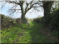
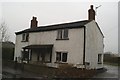
3
Hilltop Road, Acton Bridge
Within earshot of the West Coast Main Line.
Image: © Richard Webb
Taken: 11 Oct 2017
0.14 miles
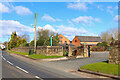
5
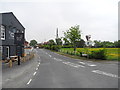
Hill Top Road, Acton Bridge
Looking north from the junction with Station Road (B5153).
Image: © John Topping
Taken: 6 Jun 2013
0.17 miles
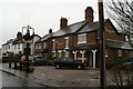
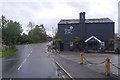
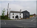
7
The Hazel Pear, near Acton Bridge Station
Image: © David Long
Taken: 7 Jan 2009
0.17 miles
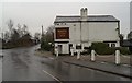
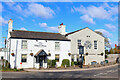
8
Hazel Pear, Acton Bridge
Hazel Pear (pub and dinning), Station Road (B5153) and Hill Top Road junction.
Image: © John Topping
Taken: 6 Jun 2013
0.17 miles
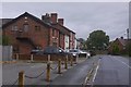
9
Hazel Pear
Public house in Acton Bridge.
Image: © Wayland Smith
Taken: 5 Mar 2022
0.18 miles