IMAGES TAKEN NEAR TO
Strawberry Lane, NORTHWICH, CW8 3QF
Introduction
This page details the photographs taken nearby to Strawberry Lane, CW8 3QF by members of the Geograph project.
The Geograph project started in 2005 with the aim of publishing, organising and preserving representative images for every square kilometre of Great Britain, Ireland and the Isle of Man.

There are currently over 7.5m images from over14,400 individuals and you can help contribute to the project by visiting https://www.geograph.org.uk
Image Map
Images are licensed for reuse under creativecommons.org/licenses/by-sa/2.0
Notes
- Clicking on the map will re-center to the selected point.
- The higher the marker number, the further away the image location is from the centre of the postcode.
Image Listing (15 Images Found)
Images are licensed for reuse under creativecommons.org/licenses/by-sa/2.0
Image
Details
Distance
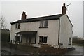
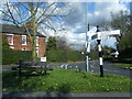
3
Pepper Street, Hill Top Road, Acton Bridge
Image: © Gary Rogers
Taken: 21 Apr 2016
0.10 miles
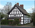
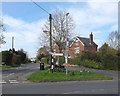
6
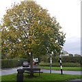
Triangle and tree, Acton Bridge
A typical rural road grass triangle. Have a guess: the tree was planted for 1977 Jubilee?
Image: © Richard Webb
Taken: 11 Oct 2017
0.11 miles
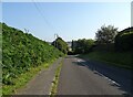
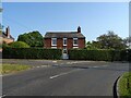
8
Junction of Cliff Road and Hill Top Road, Acton Bridge
Image: © Gary Rogers
Taken: 21 Apr 2016
0.11 miles