IMAGES TAKEN NEAR TO
Sandy Lane, NORTHWICH, CW8 3PX
Introduction
This page details the photographs taken nearby to Sandy Lane, CW8 3PX by members of the Geograph project.
The Geograph project started in 2005 with the aim of publishing, organising and preserving representative images for every square kilometre of Great Britain, Ireland and the Isle of Man.

There are currently over 7.5m images from over14,400 individuals and you can help contribute to the project by visiting https://www.geograph.org.uk
Image Map
Images are licensed for reuse under creativecommons.org/licenses/by-sa/2.0
Notes
- Clicking on the map will re-center to the selected point.
- The higher the marker number, the further away the image location is from the centre of the postcode.
Image Listing (10 Images Found)
Images are licensed for reuse under creativecommons.org/licenses/by-sa/2.0
Image
Details
Distance
1
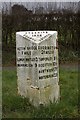
Old Milepost by the B5142, Sandy Lane, Weaverham
Cast iron post by the B5142 (was A49), in parish of Weaverham (Vale Royal District), North of Merebank, on grass verge, on South West side of road. Cast iron CCC1896, erected by the County Council in the 19th century.
Inscription reads:-
: ACTON BRIDGE / 1 MILE / LOWER WHITLEY 3 / WARRINGTON 9 : : CHESHIRE / 1896 / COUNTY COUNCIL : : CUDDINGTON / 2¼ MILES / TARPORLEY 8½ / BEESTON 10½ / NANTWICH 17¾ / WHITCHURCH 22½ :
Maker:-
: W H SMITH & CO / MAKERS / WHITCHURCH :
Milestone Society National ID: CH_WAWC09
Image: © J Higgins
Taken: 1 May 2004
0.13 miles
2
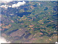
Weaverham from the air
Looking west from above Great Budworth. Weaverham is at lower left. Both the Weaver Navigation and Trent & Mersey Canals can be made out, especially where their lines converge with the A49 at the lower centre of the image.
Image: © M J Richardson
Taken: 3 Jun 2015
0.14 miles
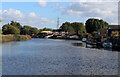
3
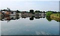
Riverside houses off Sandy Lane
On the south bank of the River Weaver, north-west of Weaverham.
Image: © Christine Johnstone
Taken: 13 Sep 2016
0.17 miles
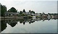
4
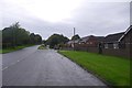
Sandy Lane, Weaverham
The River Weaver runs behind the bungalows. This was once the A49 before the bypass was built.
Image: © Richard Webb
Taken: 11 Oct 2017
0.20 miles
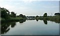
5
The River Weaver, north-west of Weaverham
Looking downstream [locally west].
Image: © Christine Johnstone
Taken: 13 Sep 2016
0.20 miles
6
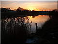
The Weaver Navigation at dusk north of Weaverham
Image: © Colin Park
Taken: 29 Nov 2010
0.23 miles
7
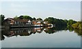
Bungalows on the south bank of the River Weaver
On Sandy Lane [B5142], north-west of Weaverham.
Image: © Christine Johnstone
Taken: 13 Sep 2016
0.24 miles
8
River Weaver, south of Bradleymeadow Wood
Looking downstream [locally south-west].
Image: © Christine Johnstone
Taken: 13 Sep 2016
0.24 miles
9
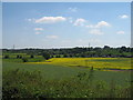
Weaver Valley from Trent-Mersey Canal
Looking across farmland to the River Weaver valley from the Trent-Mersey Canal towpath.
Image: © Sue Adair
Taken: 31 May 2009
0.24 miles