IMAGES TAKEN NEAR TO
St. Marys Avenue, NORTHWICH, CW8 3NY
Introduction
This page details the photographs taken nearby to St. Marys Avenue, CW8 3NY by members of the Geograph project.
The Geograph project started in 2005 with the aim of publishing, organising and preserving representative images for every square kilometre of Great Britain, Ireland and the Isle of Man.

There are currently over 7.5m images from over14,400 individuals and you can help contribute to the project by visiting https://www.geograph.org.uk
Image Map
Images are licensed for reuse under creativecommons.org/licenses/by-sa/2.0
Notes
- Clicking on the map will re-center to the selected point.
- The higher the marker number, the further away the image location is from the centre of the postcode.
Image Listing (10 Images Found)
Images are licensed for reuse under creativecommons.org/licenses/by-sa/2.0
Image
Details
Distance
1
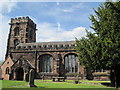
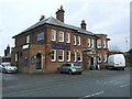
St Mary's Church, Weaverham
St Mary's Church has been a place of worship since Saxon times and is
mentioned in the Domesday Book. The tower is 15C while the remainder is late 16C.
Image: © Sue Adair
Taken: 20 Jun 2011
0.12 miles
6
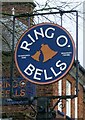
Sign for the Ring O' Bells public house, Weaverham
Image: © JThomas
Taken: 20 Mar 2024
0.23 miles
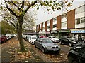
8
Theo's Fish and Chips, Northwich Road, Weaverham
Image: © Mark Anderson
Taken: 6 Oct 2018
0.24 miles
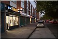
10
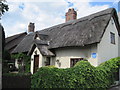
Raintub Cottage
The 17C Raintub Cottage, reputedly the oldest surviving property in Weaverham.
Image: © Sue Adair
Taken: 20 Jun 2011
0.25 miles