IMAGES TAKEN NEAR TO
Alder Road, NORTHWICH, CW8 3DS
Introduction
This page details the photographs taken nearby to Alder Road, CW8 3DS by members of the Geograph project.
The Geograph project started in 2005 with the aim of publishing, organising and preserving representative images for every square kilometre of Great Britain, Ireland and the Isle of Man.

There are currently over 7.5m images from over14,400 individuals and you can help contribute to the project by visiting https://www.geograph.org.uk
Image Map
Images are licensed for reuse under creativecommons.org/licenses/by-sa/2.0
Notes
- Clicking on the map will re-center to the selected point.
- The higher the marker number, the further away the image location is from the centre of the postcode.
Image Listing (6 Images Found)
Images are licensed for reuse under creativecommons.org/licenses/by-sa/2.0
Image
Details
Distance
1
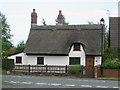
School Bank Cottage, Weaverham
Thatched cottage in Weaverham.
Image: © Lizzie
Taken: 10 Jun 2005
0.07 miles
2
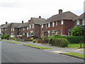
Post war council housing
Lime Avenue, Weaverham post war council housing now mainly owner occupied. A mixture of semi- detached houses and blocks of four.
Image: © Lizzie
Taken: 12 Jun 2005
0.07 miles
3
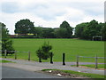
View of Weaverham High School
View across the football pitch towards Weaverham High School.
Image: © Lizzie
Taken: 12 Jun 2005
0.07 miles
4
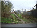
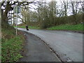
Network Rail access to West Coast Main Line off Gorstage Lane
Image: © JThomas
Taken: 20 Mar 2024
0.24 miles
6
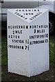
Old Milestone, B5153, Northwich Road, Weaverham
The milestone is located outside No 30 on the grass verge, on the South West side of road. Parish of Weaverham (Vale Royal District). Cast iron post, cast iron CCC1898 design, erected by the County Council in the 19th century.
Inscription reads:-
: WEAVERHAM / ¼ MILE / ACTON / STATION 1¼ / FRODSHAM 7½ : : CHESHIRE / 1898 / COUNTY COUNCIL : : NORTHWICH / 3 MILES / KNUTSFORD 10 / ALTRINCHAM 15 :
Maker:-
: W H SMITH & CO / MAKERS / WHITCHURCH :
Milestone Society National ID: CH_NTFR03
Image: © John Haynes
Taken: 1 May 2004
0.25 miles