IMAGES TAKEN NEAR TO
Millington Lane, NORTHWICH, CW8 2SU
Introduction
This page details the photographs taken nearby to Millington Lane, CW8 2SU by members of the Geograph project.
The Geograph project started in 2005 with the aim of publishing, organising and preserving representative images for every square kilometre of Great Britain, Ireland and the Isle of Man.

There are currently over 7.5m images from over14,400 individuals and you can help contribute to the project by visiting https://www.geograph.org.uk
Image Map
Images are licensed for reuse under creativecommons.org/licenses/by-sa/2.0
Notes
- Clicking on the map will re-center to the selected point.
- The higher the marker number, the further away the image location is from the centre of the postcode.
Image Listing (17 Images Found)
Images are licensed for reuse under creativecommons.org/licenses/by-sa/2.0
Image
Details
Distance
2
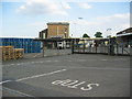
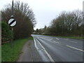
Ski yogurt factory
Ski yogurt factory on the A49(T) south of Weaverham
Image: © Lizzie
Taken: 10 Jun 2005
0.08 miles
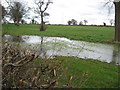
3
Marshy ground-the demise of a former brook
Image: © Dr Duncan Pepper
Taken: 27 Mar 2010
0.14 miles
6
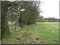
Field edge boundary
The course of the former brook is clearly visible to the left of the hedge.
Image: © Dr Duncan Pepper
Taken: 27 Mar 2010
0.15 miles
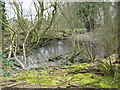
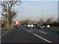
7
Pond with pylon
Was once the source of a brook but said brook soon vanishes.
Image: © Dr Duncan Pepper
Taken: 27 Mar 2010
0.16 miles
9
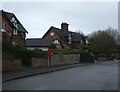
Cottages on Warrington Road, Bryn
Showing position of Postbox No. CW8 91.
See Image] for postbox.
Image: © JThomas
Taken: 20 Mar 2024
0.18 miles
10
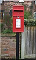
Elizabeth II postbox on Warrington Road, Bryn
Postbox No. CW8 91.
See Image] for context.
Image: © JThomas
Taken: 20 Mar 2024
0.18 miles