IMAGES TAKEN NEAR TO
The Courtyard, NORTHWICH, CW8 2SS
Introduction
This page details the photographs taken nearby to The Courtyard, CW8 2SS by members of the Geograph project.
The Geograph project started in 2005 with the aim of publishing, organising and preserving representative images for every square kilometre of Great Britain, Ireland and the Isle of Man.

There are currently over 7.5m images from over14,400 individuals and you can help contribute to the project by visiting https://www.geograph.org.uk
Image Map
Images are licensed for reuse under creativecommons.org/licenses/by-sa/2.0
Notes
- Clicking on the map will re-center to the selected point.
- The higher the marker number, the further away the image location is from the centre of the postcode.
Image Listing (8 Images Found)
Images are licensed for reuse under creativecommons.org/licenses/by-sa/2.0
Image
Details
Distance
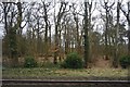
2
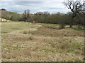
Hefferston Grange
Farmland, Hefferston Grange, to the North West of the A49, between Cuddington and Weaverham.
Image: © Jo Lxix
Taken: 10 May 2006
0.09 miles
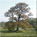
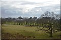
3
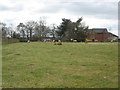
Sheep paddock at Hefferston Grange
Image: © Dr Duncan Pepper
Taken: 27 Mar 2010
0.11 miles
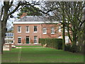
6
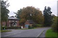
Hefferston Rise
A road servicing a housing estate surrounding Hefferston Hall.
Image: © Richard Webb
Taken: 11 Oct 2017
0.19 miles
7
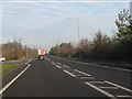
A49 at Grange Lane
This section of the A49 has been improved over the years (though sadly not dualled), replacing Grange Lane as the through route.
Image: © Peter Whatley
Taken: 17 Jan 2012
0.22 miles