IMAGES TAKEN NEAR TO
Sandown Crescent, NORTHWICH, CW8 2QN
Introduction
This page details the photographs taken nearby to Sandown Crescent, CW8 2QN by members of the Geograph project.
The Geograph project started in 2005 with the aim of publishing, organising and preserving representative images for every square kilometre of Great Britain, Ireland and the Isle of Man.

There are currently over 7.5m images from over14,400 individuals and you can help contribute to the project by visiting https://www.geograph.org.uk
Image Map
Images are licensed for reuse under creativecommons.org/licenses/by-sa/2.0
Notes
- Clicking on the map will re-center to the selected point.
- The higher the marker number, the further away the image location is from the centre of the postcode.
Image Listing (6 Images Found)
Images are licensed for reuse under creativecommons.org/licenses/by-sa/2.0
Image
Details
Distance
1
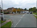
Shopping centre on Mere Lane ,Sandiway
Image: © Raymond Knapman
Taken: 26 Sep 2013
0.09 miles
4
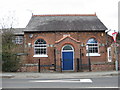
Bryn primitive methodist chapel
Now a private house-nicely preserved.
Image: © Dr Duncan Pepper
Taken: 27 Mar 2010
0.22 miles
5
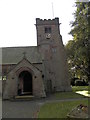
St John's Church, Sandiway
Tower and porch of local church
Image: © Chris Cursley
Taken: 9 Oct 2016
0.24 miles
6

OS benchmark on Sandiway church
Cut mark on tower of local church, very weathered and difficult to spot.
Image: © Chris Cursley
Taken: 9 Oct 2016
0.24 miles