IMAGES TAKEN NEAR TO
Forest Road, NORTHWICH, CW8 2LD
Introduction
This page details the photographs taken nearby to Forest Road, CW8 2LD by members of the Geograph project.
The Geograph project started in 2005 with the aim of publishing, organising and preserving representative images for every square kilometre of Great Britain, Ireland and the Isle of Man.

There are currently over 7.5m images from over14,400 individuals and you can help contribute to the project by visiting https://www.geograph.org.uk
Image Map
Images are licensed for reuse under creativecommons.org/licenses/by-sa/2.0
Notes
- Clicking on the map will re-center to the selected point.
- The higher the marker number, the further away the image location is from the centre of the postcode.
Image Listing (39 Images Found)
Images are licensed for reuse under creativecommons.org/licenses/by-sa/2.0
Image
Details
Distance
1
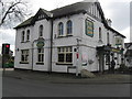
The White Barn at Cuddington
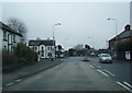
At the Warrington Road [A49]/Norley Road cross roads.
Image: © M J Richardson
Taken: 20 Mar 2012
0.00 miles
3
The White Barn, Cuddington
The White Barn in Cuddington at the junction of the A49 and Norley Road.
Image: © Jeff Buck
Taken: 29 May 2023
0.01 miles
4
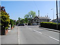
Traffic Lights at Cuddington
Cuddington Heath is a village and (as Cuddington) a civil parish in Cheshire. The village is close to the border with Wales and the nearest large town is Wrexham, about ten miles to the west. At the 2011 Census, the parish had a population of 171 (http://www.neighbourhood.statistics.gov.uk/dissemination/LeadKeyFigures.do?a=7&b=11122530&c=Cuddington&d=16&e=62&g=6407150&i=1001x1003x1032x1004&m=0&r=1&s=1467370011654&enc=1&nsjs=true&nsck=false&nssvg=false&nswid=1920 Office for National Statistics).
Image: © David Dixon
Taken: 11 Apr 2016
0.01 miles
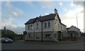
6
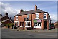
Houses and shop at Cuddington
The plaque on the wall reads "The Hawthorns 1896". Presumably this was built as a terrace of two houses and a shop (now Karma Rooms hairdressing and White Hart Serenity beauty) since the doorways match in style
Image: © David Smith
Taken: 30 Sep 2016
0.01 miles
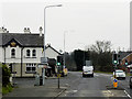
7
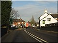
Cuddington crossroads from the A49 railway bridge
Image: © Peter Whatley
Taken: 17 Jan 2012
0.02 miles
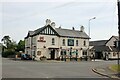
8
Norley Road, Cuddington
Approaching The A49 junction, Warrington Road (left) and Forest Road (right). Renovation work being carried out on The White Barn PH.
Image: © John Topping
Taken: 6 Jun 2013
0.02 miles
9
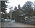
Cuddington Railway Station Buildings
Disused ticket office and former Stationmaster's Cottage viewed from the station yard. See Image
Image: © Jo Lxix
Taken: 26 Apr 2006
0.02 miles
10
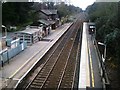
Cuddington Railway Station
View from Norley Road Bridge Eastbound, Chester to Altrincham line. Station founded 1869, still operational but now unmanned. Buildings visible on Eastbound platform are - modern-day plexiglass shelter, former ticket office (greater part demolished and remainder roofless), porters' room, lamp store, and waiting room, the latter all integral with the rear of the former Stationmaster's Cottage (now privatised). Fairly typical of Cheshire Lines Committee village stations, both in building layout and present day outcome! At the end of the platform stood a signal box, and the waste ground as far as the bridge was previously sidings and a goods yard serving the village.
Vehicles exit the station at Image Crossroads.
Image: © Jo Lxix
Taken: 26 Apr 2006
0.02 miles