IMAGES TAKEN NEAR TO
Norley Road, NORTHWICH, CW8 2JW
Introduction
This page details the photographs taken nearby to Norley Road, CW8 2JW by members of the Geograph project.
The Geograph project started in 2005 with the aim of publishing, organising and preserving representative images for every square kilometre of Great Britain, Ireland and the Isle of Man.

There are currently over 7.5m images from over14,400 individuals and you can help contribute to the project by visiting https://www.geograph.org.uk
Image Map
Images are licensed for reuse under creativecommons.org/licenses/by-sa/2.0
Notes
- Clicking on the map will re-center to the selected point.
- The higher the marker number, the further away the image location is from the centre of the postcode.
Image Listing (22 Images Found)
Images are licensed for reuse under creativecommons.org/licenses/by-sa/2.0
Image
Details
Distance
1
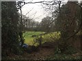
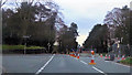
Off Norley Road, Sandiway
Across the A556 from Pettypool Park.
Image: © Richard Webb
Taken: 17 Feb 2019
0.08 miles
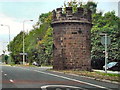
2
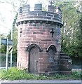
The Round Tower
Closer view of Image, seen from across the Westbound (newer) carriageway.
Image: © Jo Lxix
Taken: 5 May 2006
0.09 miles
3
The Round Tower, Sandiway
Travellers on the A556, Chester Road, Sandiway, will recognise this prominent local landmark near the junction with Norley Road. The Round Tower, more properly and traditionally known as The Round Lodge, was built circa 1816 of Cheshire sandstone as a gate lodge to the nearby Vale Royal Estate. It became stranded in the central reservation, as seen here from the eastbound view towards Speedwell, when the road was expanded to dual carriageway during the 1930's. Original carriageway is the one on the left.
Image: © Jo Lxix
Taken: 5 May 2006
0.09 miles
4
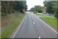
Approach to junction for Cuddington on the A556
Image: © Raymond Knapman
Taken: 26 Sep 2013
0.09 miles
6
The Round Tower, Sandiway
The Round Tower Lodge is situated in the central reservation of the A556 in Sandiway. The tower is all that survives of a gate lodge to the house of Vale Royal Abbey. It is a Grade II listed building.
Image: © David Dixon
Taken: 4 Sep 2010
0.10 miles
7
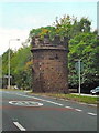
A556, The Round Tower, Sandiway
The Round Tower Lodge is situated in the central reservation of the A556 in Sandiway. The tower is all that survives of a gate lodge to the house of Vale Royal Abbey. It is a Grade II listed building.
Image: © David Dixon
Taken: 4 Sep 2010
0.10 miles
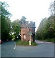
8
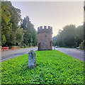
Former Toll House, Sandiway
In the middle of the dual carriageway of the A56, Chester Road, which was widened during the 1930s. The property is all that survives from the Lodge for the Vale Royal Estate. It served the Northwich & Kensall Turnpike Trust in the 19ᵗʰ C.
Grade II listed Building No 1227728 https://historicengland.org.uk/listing/the-list/list-entry/1227728
Milestone Society National ID: CH.NOR
Image: © Nigel Upton
Taken: 29 Aug 2023
0.10 miles
9
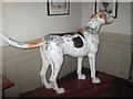
The Blue Cap - Foxhound
Inside the Blue Cap pub
Image: © John Firth
Taken: 14 Apr 2012
0.15 miles
10
The Blue Cap Chester Road Sandiway
The statue of the dog which was once outside is now inside the door.
Image: © John Firth
Taken: 14 Apr 2012
0.16 miles