IMAGES TAKEN NEAR TO
Churchfields, NORTHWICH, CW8 2JS
Introduction
This page details the photographs taken nearby to Churchfields, CW8 2JS by members of the Geograph project.
The Geograph project started in 2005 with the aim of publishing, organising and preserving representative images for every square kilometre of Great Britain, Ireland and the Isle of Man.

There are currently over 7.5m images from over14,400 individuals and you can help contribute to the project by visiting https://www.geograph.org.uk
Image Map
Images are licensed for reuse under creativecommons.org/licenses/by-sa/2.0
Notes
- Clicking on the map will re-center to the selected point.
- The higher the marker number, the further away the image location is from the centre of the postcode.
Image Listing (18 Images Found)
Images are licensed for reuse under creativecommons.org/licenses/by-sa/2.0
Image
Details
Distance
1

St John the Evangelist Church in Sandiway
There's a clue in the locale name.
Image: © Dr Duncan Pepper
Taken: 27 Mar 2010
0.11 miles
2

OS benchmark on Sandiway church
Cut mark on tower of local church, very weathered and difficult to spot.
Image: © Chris Cursley
Taken: 9 Oct 2016
0.13 miles
3
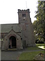
St John's Church, Sandiway
Tower and porch of local church
Image: © Chris Cursley
Taken: 9 Oct 2016
0.13 miles
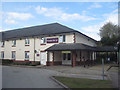
4
Premier Inn on Chester Road, Northwich
Image: © Darrin Antrobus
Taken: 9 Apr 2009
0.15 miles
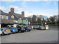
5
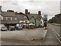
View from the Blue Cap on Chester Road
Image: © Darrin Antrobus
Taken: 9 Apr 2009
0.16 miles
6
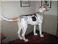
The Blue Cap - Foxhound
Inside the Blue Cap pub
Image: © John Firth
Taken: 14 Apr 2012
0.17 miles
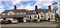
7
The Blue Cap Chester Road Sandiway
The statue of the dog which was once outside is now inside the door.
Image: © John Firth
Taken: 14 Apr 2012
0.17 miles
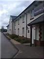
9
The Premier Inn at Sandiway
Off Chester Road next to The Blue Cap
Image: © John Firth
Taken: 14 Apr 2012
0.17 miles