IMAGES TAKEN NEAR TO
Chester Road, NORTHWICH, CW8 2JL
Introduction
This page details the photographs taken nearby to Chester Road, CW8 2JL by members of the Geograph project.
The Geograph project started in 2005 with the aim of publishing, organising and preserving representative images for every square kilometre of Great Britain, Ireland and the Isle of Man.

There are currently over 7.5m images from over14,400 individuals and you can help contribute to the project by visiting https://www.geograph.org.uk
Image Map
Images are licensed for reuse under creativecommons.org/licenses/by-sa/2.0
Notes
- Clicking on the map will re-center to the selected point.
- The higher the marker number, the further away the image location is from the centre of the postcode.
Image Listing (7 Images Found)
Images are licensed for reuse under creativecommons.org/licenses/by-sa/2.0
Image
Details
Distance
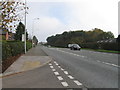
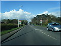
3
Chester road at Oakmere
A556 west approaching junction with Farm Road
Image: © John Firth
Taken: 15 Apr 2012
0.08 miles
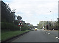
6
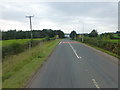
The A556 approach to Oakmere junction with the B5152
Image: © Raymond Knapman
Taken: 26 Sep 2013
0.17 miles
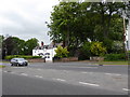
7
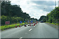
Roadworks on Chester Road
The A556 is down to one active lane, causing queues in both directions.
Image: © Bill Boaden
Taken: 2 Sep 2017
0.19 miles