IMAGES TAKEN NEAR TO
Chrimes Drive, NORTHWICH, CW8 2HH
Introduction
This page details the photographs taken nearby to Chrimes Drive, CW8 2HH by members of the Geograph project.
The Geograph project started in 2005 with the aim of publishing, organising and preserving representative images for every square kilometre of Great Britain, Ireland and the Isle of Man.

There are currently over 7.5m images from over14,400 individuals and you can help contribute to the project by visiting https://www.geograph.org.uk
Image Map
Images are licensed for reuse under creativecommons.org/licenses/by-sa/2.0
Notes
- Clicking on the map will re-center to the selected point.
- The higher the marker number, the further away the image location is from the centre of the postcode.
Image Listing (3 Images Found)
Images are licensed for reuse under creativecommons.org/licenses/by-sa/2.0
Image
Details
Distance
1
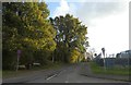
Waste Lane
This unusually named road leads through Bowyer's Waste to Waste Farm
Image: © David Smith
Taken: 24 Oct 2019
0.12 miles
2
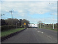
A556 west entering Oakmere 50 limit
Waste Lane on left at brow of hill. Discover More warehouse if white building straight ahead
Image: © John Firth
Taken: 15 Apr 2012
0.14 miles
3
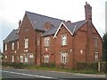
Court House, Oakmere
On A556, Chester Road.
Built in 1892 (prior to this time magistrates sat in a room at the nearby Abbey Arms Hotel), originally comprising a courthouse, police station and cells. Disused since c. 1987, currently boarded up and derelict.
Image: © Jo Lxix
Taken: 1 Jul 2006
0.16 miles