IMAGES TAKEN NEAR TO
Dalefords Lane, NORTHWICH, CW8 2GW
Introduction
This page details the photographs taken nearby to Dalefords Lane, CW8 2GW by members of the Geograph project.
The Geograph project started in 2005 with the aim of publishing, organising and preserving representative images for every square kilometre of Great Britain, Ireland and the Isle of Man.

There are currently over 7.5m images from over14,400 individuals and you can help contribute to the project by visiting https://www.geograph.org.uk
Image Map
Images are licensed for reuse under creativecommons.org/licenses/by-sa/2.0
Notes
- Clicking on the map will re-center to the selected point.
- The higher the marker number, the further away the image location is from the centre of the postcode.
Image Listing (5 Images Found)
Images are licensed for reuse under creativecommons.org/licenses/by-sa/2.0
Image
Details
Distance
1
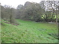
A narrow wooded valley below Beech Tree farm
Image: © Dr Duncan Pepper
Taken: 11 Nov 2011
0.06 miles
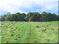
3
A prominent wooded mound beside Dalefords Lane
Image: © Dr Duncan Pepper
Taken: 11 Nov 2011
0.11 miles
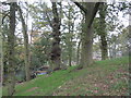
4
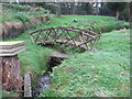
Footbridge over a small stream below Beech Tree farm that feeds into Petty Pool lake
Image: © Dr Duncan Pepper
Taken: 11 Nov 2011
0.11 miles