IMAGES TAKEN NEAR TO
Hornbeam Drive, NORTHWICH, CW8 2GA
Introduction
This page details the photographs taken nearby to Hornbeam Drive, CW8 2GA by members of the Geograph project.
The Geograph project started in 2005 with the aim of publishing, organising and preserving representative images for every square kilometre of Great Britain, Ireland and the Isle of Man.

There are currently over 7.5m images from over14,400 individuals and you can help contribute to the project by visiting https://www.geograph.org.uk
Image Map
Images are licensed for reuse under creativecommons.org/licenses/by-sa/2.0
Notes
- Clicking on the map will re-center to the selected point.
- The higher the marker number, the further away the image location is from the centre of the postcode.
Image Listing (15 Images Found)
Images are licensed for reuse under creativecommons.org/licenses/by-sa/2.0
Image
Details
Distance
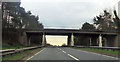
4
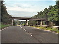
Chester Road Bridge, A556
Bridge carrying the A559 (Chester Road) over the A556 at Heyesmere.
Image: © David Dixon
Taken: 4 Sep 2010
0.19 miles
6
Roadbridge over the A556 Chester Road
Image: © Dr Duncan Pepper
Taken: 27 Mar 2010
0.19 miles
8
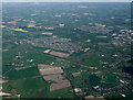
Weaverham from the air
Viewed from a Manchester bound flight from Prague.
Image: © Thomas Nugent
Taken: 18 Apr 2014
0.21 miles
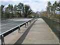
9

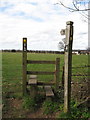
Footpath beside the A556 Chester road
Image: © Dr Duncan Pepper
Taken: 27 Mar 2010
0.22 miles
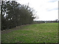
10
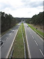
The A556 Chester Road looking West
Image: © Dr Duncan Pepper
Taken: 27 Mar 2010
0.23 miles