IMAGES TAKEN NEAR TO
Kensington Crescent, NORTHWICH, CW8 2FH
Introduction
This page details the photographs taken nearby to Kensington Crescent, CW8 2FH by members of the Geograph project.
The Geograph project started in 2005 with the aim of publishing, organising and preserving representative images for every square kilometre of Great Britain, Ireland and the Isle of Man.

There are currently over 7.5m images from over14,400 individuals and you can help contribute to the project by visiting https://www.geograph.org.uk
Image Map
Images are licensed for reuse under creativecommons.org/licenses/by-sa/2.0
Notes
- Clicking on the map will re-center to the selected point.
- The higher the marker number, the further away the image location is from the centre of the postcode.
Image Listing (12 Images Found)
Images are licensed for reuse under creativecommons.org/licenses/by-sa/2.0
Image
Details
Distance
1
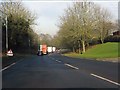
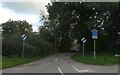
Approaching roadworks north of Cuddington on the A49
Image: © Peter Whatley
Taken: 17 Jan 2012
0.10 miles
2
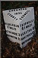
Old Milepost by the A49 at Bryn, Cuddington
Cast iron post by the A49, in parish of Cuddington (Vale Royal District), by Bryn Works, on grass verge, on West side of road. Cast iron CCC1896, erected by the County Council in the 19th century.
Inscription reads:-
: WEAVERHAM / 1¾ MILES / ACTON BRIDGE 3 / WARRINGTON 11 : : CHESHIRE / 1896 / COUNTY COUNCIL : : TARPORLEY / 6½ MILES / BEESTON 8½ / NANTWICH 15¾ / WHITCHURCH 20½ :
Maker:-
: W H SMITH & CO / MAKERS / WHITCHURCH :
Milestone Society National ID: CH_WAWC11
Image: © J Higgins
Taken: 1 May 2004
0.14 miles
3
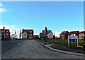
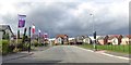
Eden Grange - New Housing Development
Built by Taylor Wimpey
Image: © Anthony Parkes
Taken: 1 Mar 2014
0.14 miles
4
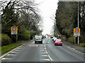
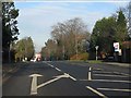
A49 Entering Cuddington
Cuddington Heath is a village and (as Cuddington) a civil parish in Cheshire. The village is close to the border with Wales and the nearest large town is Wrexham, about ten miles to the west. At the 2011 Census, the parish had a population of 171 (http://www.neighbourhood.statistics.gov.uk/dissemination/LeadKeyFigures.do?a=7&b=11122530&c=Cuddington&d=16&e=62&g=6407150&i=1001x1003x1032x1004&m=0&r=1&s=1467370011654&enc=1&nsjs=true&nsck=false&nssvg=false&nswid=1920 Office for National Statistics).
Image: © David Dixon
Taken: 11 Apr 2016
0.20 miles
5
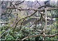
Lower Mill Pool, Cuddington
Mill pool, now disused and landscaped, formerly serving Lower Mill, off Cuddington Lane.
Viewed from public footpath between Warrington Road and Image
Image: © Jo Lxix
Taken: 26 Apr 2006
0.21 miles
6
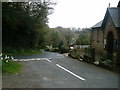
Pinfold Hollow, Cuddington
Cuddington Lane leading down into Pinfold Hollow and Cuddington Brook, viewed from outside Image
Image: © Jo Lxix
Taken: 26 Apr 2006
0.21 miles
8
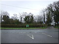
Cuddington Lane junction with the A49, Bryn
Image: © JThomas
Taken: 20 Mar 2024
0.22 miles