IMAGES TAKEN NEAR TO
Hogshead Lane, NORTHWICH, CW8 2ET
Introduction
This page details the photographs taken nearby to Hogshead Lane, CW8 2ET by members of the Geograph project.
The Geograph project started in 2005 with the aim of publishing, organising and preserving representative images for every square kilometre of Great Britain, Ireland and the Isle of Man.

There are currently over 7.5m images from over14,400 individuals and you can help contribute to the project by visiting https://www.geograph.org.uk
Image Map
Images are licensed for reuse under creativecommons.org/licenses/by-sa/2.0
Notes
- Clicking on the map will re-center to the selected point.
- The higher the marker number, the further away the image location is from the centre of the postcode.
Image Listing (8 Images Found)
Images are licensed for reuse under creativecommons.org/licenses/by-sa/2.0
Image
Details
Distance
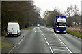
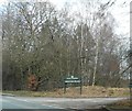
3
A49 approaching Abbots Moss Nursery entrance
Looking north
Image: © John Firth
Taken: 14 Apr 2012
0.10 miles
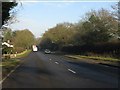
5
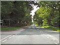
A49, Tarporley Road
Passing the entrance to Abbots Moss Nursery
Image: © David Dixon
Taken: 4 Sep 2010
0.11 miles
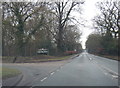
6
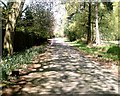
Hogshead Lane, Oakmere
Hogshead Lane on a sunny Spring day, viewed from junction with A49 near Abbots Moss towards Crabtree Green junction with A556.
Image: © Jo Lxix
Taken: 10 May 2006
0.15 miles
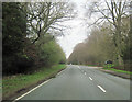
7
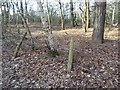
Hogshead Wood
A quarry is mapped beyond a roadside strip of mature woodland. Hogshead Lane has been realigned here to give a safer junction onto the A49.
Image: © Richard Webb
Taken: 30 Mar 2019
0.16 miles