IMAGES TAKEN NEAR TO
Overdale Lane, NORTHWICH, CW8 2EL
Introduction
This page details the photographs taken nearby to Overdale Lane, CW8 2EL by members of the Geograph project.
The Geograph project started in 2005 with the aim of publishing, organising and preserving representative images for every square kilometre of Great Britain, Ireland and the Isle of Man.

There are currently over 7.5m images from over14,400 individuals and you can help contribute to the project by visiting https://www.geograph.org.uk
Image Map
Images are licensed for reuse under creativecommons.org/licenses/by-sa/2.0
Notes
- Clicking on the map will re-center to the selected point.
- The higher the marker number, the further away the image location is from the centre of the postcode.
Image Listing (9 Images Found)
Images are licensed for reuse under creativecommons.org/licenses/by-sa/2.0
Image
Details
Distance
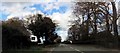
1
A556 west approaching Overdale Lane junction
The junction can just be seen on the left. On the right is Lobslack Wood
Image: © John Firth
Taken: 15 Apr 2012
0.11 miles
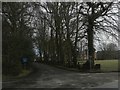
2
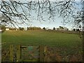
Private land at Forest View
A sign on a gate deters users of the Whitegate Way from trespassing.
Image: © Stephen Craven
Taken: 29 Dec 2021
0.12 miles
3
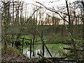
Pond near Chester Road
This part of Cheshire has many small ponds or meres like this, mostly of natural origin.
Image: © Stephen Craven
Taken: 29 Dec 2021
0.16 miles
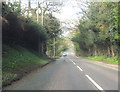
4
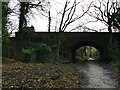
Chester Road bridge over the Whitegate Way
The bridge carries the A556 (Manchester to Chester) road. There are steps to the left connecting the road and bridleway.
Image: © Stephen Craven
Taken: 29 Dec 2021
0.17 miles
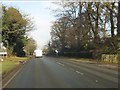
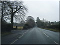
6
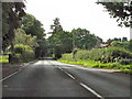
Tarporley Road (A49)
Passing the junction with Overdale Lane.
Image: © David Dixon
Taken: 4 Sep 2010
0.21 miles