IMAGES TAKEN NEAR TO
Chester Road, NORTHWICH, CW8 2DL
Introduction
This page details the photographs taken nearby to Chester Road, CW8 2DL by members of the Geograph project.
The Geograph project started in 2005 with the aim of publishing, organising and preserving representative images for every square kilometre of Great Britain, Ireland and the Isle of Man.

There are currently over 7.5m images from over14,400 individuals and you can help contribute to the project by visiting https://www.geograph.org.uk
Image Map
Images are licensed for reuse under creativecommons.org/licenses/by-sa/2.0
Notes
- Clicking on the map will re-center to the selected point.
- The higher the marker number, the further away the image location is from the centre of the postcode.
Image Listing (10 Images Found)
Images are licensed for reuse under creativecommons.org/licenses/by-sa/2.0
Image
Details
Distance
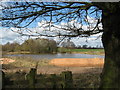
2
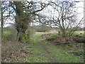
Hunt's Lane with ancient oaks
I suspect this byway is quite ancient.
Image: © Dr Duncan Pepper
Taken: 27 Mar 2010
0.09 miles
3
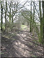
Hunt's Lane heading West to Sandiway
Image: © Dr Duncan Pepper
Taken: 27 Mar 2010
0.15 miles
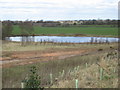
4
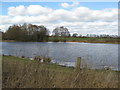
Flooded quarry workings-now a private fishing club
Image: © Dr Duncan Pepper
Taken: 27 Mar 2010
0.16 miles
5
The eponymous sandy land that named the locale Sandiway
Image: © Dr Duncan Pepper
Taken: 27 Mar 2010
0.17 miles
6
Lake formed in old sand quarry workings
Image: © Dr Duncan Pepper
Taken: 27 Mar 2010
0.17 miles
8

Forest Hill
Lots of contours on the Ordnance Survey map, but the hill has been quarried for sand.
Image: © Richard Webb
Taken: 17 Feb 2019
0.23 miles
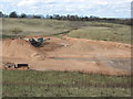
9
Extensive & deep sand quarry
A clue- the local village is Sandiway
Image: © Dr Duncan Pepper
Taken: 27 Mar 2010
0.23 miles
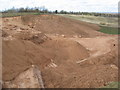
10

Quarry road, Forest Hill
Serving a sand quarry near Sandiway.
Image: © Richard Webb
Taken: 17 Feb 2019
0.24 miles