IMAGES TAKEN NEAR TO
Thompson Green, NORTHWICH, CW8 2DG
Introduction
This page details the photographs taken nearby to Thompson Green, CW8 2DG by members of the Geograph project.
The Geograph project started in 2005 with the aim of publishing, organising and preserving representative images for every square kilometre of Great Britain, Ireland and the Isle of Man.

There are currently over 7.5m images from over14,400 individuals and you can help contribute to the project by visiting https://www.geograph.org.uk
Image Map
Images are licensed for reuse under creativecommons.org/licenses/by-sa/2.0
Notes
- Clicking on the map will re-center to the selected point.
- The higher the marker number, the further away the image location is from the centre of the postcode.
Image Listing (37 Images Found)
Images are licensed for reuse under creativecommons.org/licenses/by-sa/2.0
Image
Details
Distance
1
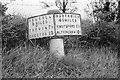
Old Milepost by the A556, Chester Road, Oakmere Parish
Old domed open book by the A556, in parish of Oakmere (Vale Royal District), Chester Road; 120m West of Hillcroft, by the road.
May be lost.
Inscription reads:-
: KELSALL / 5 MILES / TARVIN 7½ / CHESTER 13 : : NORTHWICH / 4½ MILES / KNUTSFORD 11½ / ALTRINCHAM 16½ :
Milestone Society National ID: CH_CHKF13.
Image: © Milestone Society
Taken: Unknown
0.06 miles
3
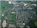
Sandiway from the air
Viewed from a Manchester bound flight from Prague.
Image: © Thomas Nugent
Taken: 18 Apr 2014
0.09 miles
6
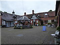
Blakemere Village
Blaklemere Hall and its stable blocks were built in 1878, commandeered during WW2, and then the hall was demolished in the 1950's. The remaining buildings were converted into retail and leisure units in the mid 1990s
Image: © Eirian Evans
Taken: 25 May 2016
0.14 miles
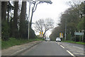
7
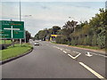
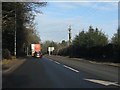
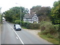
Chester Road (A556)
Chester Road, near to the junction with Tarporley Road (A49).
Image: © David Dixon
Taken: 4 Sep 2010
0.14 miles
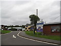
10
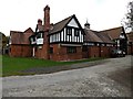
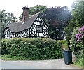
Former stable block at Blakemere Village
Converted stable block now a retail outlet of small shops.
Image: © Richard Hoare
Taken: 28 Oct 2014
0.14 miles