IMAGES TAKEN NEAR TO
Whitegate Lane, NORTHWICH, CW8 2AX
Introduction
This page details the photographs taken nearby to Whitegate Lane, CW8 2AX by members of the Geograph project.
The Geograph project started in 2005 with the aim of publishing, organising and preserving representative images for every square kilometre of Great Britain, Ireland and the Isle of Man.

There are currently over 7.5m images from over14,400 individuals and you can help contribute to the project by visiting https://www.geograph.org.uk
Image Map
Images are licensed for reuse under creativecommons.org/licenses/by-sa/2.0
Notes
- Clicking on the map will re-center to the selected point.
- The higher the marker number, the further away the image location is from the centre of the postcode.
Image Listing (4 Images Found)
Images are licensed for reuse under creativecommons.org/licenses/by-sa/2.0
Image
Details
Distance
3
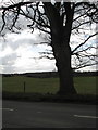
Farmland to the southwest of Northwich
Looking west from outside Earnslow Grange on Littledales Lane. The farmland slopes gently down to Petty Pool, a Cheshire mere, out of shot and out of the grid square.
Image: © michael ely
Taken: 27 Jun 2006
0.22 miles
4
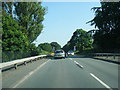
A556, Chester Road, Sandiway
Looking west from the overbridge at Heyesmere down the dual carriageway towards Chester.
Image: © michael ely
Taken: 27 Jun 2006
0.23 miles