IMAGES TAKEN NEAR TO
Chester Road, NORTHWICH, CW8 2AG
Introduction
This page details the photographs taken nearby to Chester Road, CW8 2AG by members of the Geograph project.
The Geograph project started in 2005 with the aim of publishing, organising and preserving representative images for every square kilometre of Great Britain, Ireland and the Isle of Man.

There are currently over 7.5m images from over14,400 individuals and you can help contribute to the project by visiting https://www.geograph.org.uk
Image Map (Loading...)


Getting Data...Please wait
Leaflet Map data © OpenStreetMap
Images are licensed for reuse under creativecommons.org/licenses/by-sa/2.0
Notes
- Clicking on the map will re-center to the selected point.
- The higher the marker number, the further away the image location is from the centre of the postcode.
Image Listing (6 Images Found)
Images are licensed for reuse under creativecommons.org/licenses/by-sa/2.0
Image
Details
Distance
1
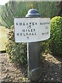
Old Milepost by the A559, Chester Road, Hartford
Cast iron post by the A559, in parish of HARTFORD (VALE ROYAL District), Chester Road; half mile West of railway station, by the road, on South side of road. Old domed open book, erected by the Northwich & Kelsall turnpike trust in the 19th century.
Inscription reads:-
: CHESTER / 13 / MILES / KELSALL / 7 : : NORTHWICH / 2½ / MILES :
Parish, Date and Maker's plaque:-
: SANDIWAY / 1833 / W.E / M :
Grade II listed.
List Entry Number: 1228373 https://historicengland.org.uk/listing/the-list/list-entry/1228373
Milestone Society National ID: CH_NTCH02
Image: © J Higgins
Taken: 1 May 2004
0.03 miles
2
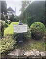
Old Milepost by the A559, Chester Road, Hartford
Cast iron post by the A559, in parish of HARTFORD (VALE ROYAL District), Chester Road; half mile West of railway station, by the road, on South side of road. Old domed open book, erected by the Northwich & Kelsall turnpike trust in the 19th century.
Inscription reads:-
: CHESTER / 13 / MILES / KELSALL / 7 : : NORTHWICH / 2½ / MILES :
Parish, Date and Maker's plaque:-
: SANDIWAY / 1833 / W.E / M :
Grade II listed.
List Entry Number: 1228373 https://historicengland.org.uk/listing/the-list/list-entry/1228373
Milestone Society National ID: CH_NTCH02
Image: © Nigel Upton
Taken: 25 Aug 2023
0.03 miles
3
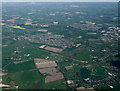
Weaverham from the air
Viewed from a Manchester bound flight from Prague.
Image: © Thomas Nugent
Taken: 18 Apr 2014
0.06 miles
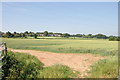
6

Footpath from Chester Rd to Hodge Lane
Image: © Richard Sandland
Taken: 11 Jul 2013
0.25 miles