IMAGES TAKEN NEAR TO
Morris Park, NORTHWICH, CW8 1SB
Introduction
This page details the photographs taken nearby to Morris Park, CW8 1SB by members of the Geograph project.
The Geograph project started in 2005 with the aim of publishing, organising and preserving representative images for every square kilometre of Great Britain, Ireland and the Isle of Man.

There are currently over 7.5m images from over14,400 individuals and you can help contribute to the project by visiting https://www.geograph.org.uk
Image Map
Images are licensed for reuse under creativecommons.org/licenses/by-sa/2.0
Notes
- Clicking on the map will re-center to the selected point.
- The higher the marker number, the further away the image location is from the centre of the postcode.
Image Listing (12 Images Found)
Images are licensed for reuse under creativecommons.org/licenses/by-sa/2.0
Image
Details
Distance
1
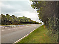
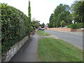
A556
Looking eastwards along the A556 from the exit of Hartford Picnic site.
Image: © David Dixon
Taken: 25 Jul 2010
0.16 miles
4
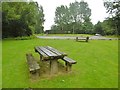
Hartford, picnic site
In a large site on a lay-by on A556 (Eastbound). Not many takers today, a rainy day.
Image: © Mike Faherty
Taken: 1 Aug 2017
0.21 miles
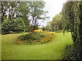
5
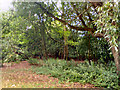
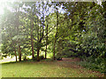
Hartford Picnic Area
Trees at the western boundary of Hartford Picnic Area.
Image: © David Dixon
Taken: 25 Jul 2010
0.21 miles
7
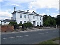
Whitehall
A large house on School Lane
Image: © Richard Webb
Taken: 30 Aug 2022
0.21 miles
8
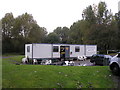
The Hartford Diner
Great Food in a nice location
Image: © Iain Lees
Taken: 5 Oct 2008
0.23 miles
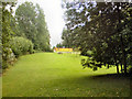
9
Hartford Picnic Area
The south western boundary of the picnic site.
Image: © David Dixon
Taken: 25 Jul 2010
0.23 miles
10
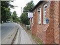
Nursery, School Lane
Hartford Nursery in an old school building. The Knowles plaque can be seen on a buttress.
Image
Image: © Richard Webb
Taken: 30 Aug 2022
0.24 miles