IMAGES TAKEN NEAR TO
William Street, WINSFORD, CW7 4EZ
Introduction
This page details the photographs taken nearby to William Street, CW7 4EZ by members of the Geograph project.
The Geograph project started in 2005 with the aim of publishing, organising and preserving representative images for every square kilometre of Great Britain, Ireland and the Isle of Man.

There are currently over 7.5m images from over14,400 individuals and you can help contribute to the project by visiting https://www.geograph.org.uk
Image Map
Images are licensed for reuse under creativecommons.org/licenses/by-sa/2.0
Notes
- Clicking on the map will re-center to the selected point.
- The higher the marker number, the further away the image location is from the centre of the postcode.
Image Listing (21 Images Found)
Images are licensed for reuse under creativecommons.org/licenses/by-sa/2.0
Image
Details
Distance
1
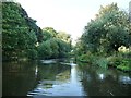
The navigable River Weaver, north of Bottom Flash
Looking downstream [locally north]. Under the control of the local council, not CRT. Navigable for full size narrowboats and links to a mooring basin provided by the local council.
Image: © Christine Johnstone
Taken: 14 Sep 2016
0.02 miles
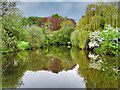
3

Weaver Navigation, Winsford Marina
Winsford Marina is just below the flash.
Image: © David Dixon
Taken: 9 May 2023
0.06 miles

5
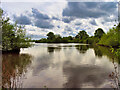
Weaver Navigation, Winsford Flash
The flash was formed from the mid-nineteenth century onwards due to subsidence caused by brine extraction. The flash, as seen today, was completed by 1887 where three brine streams converged and subsidence caused more than 100 acres of land to be flooded.
Image: © David Dixon
Taken: 9 May 2023
0.07 miles
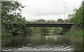
6
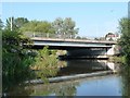
The southern of Winsford's two bridges over the Weaver
Carrying westbound traffic on the A54.
Image: © Christine Johnstone
Taken: 14 Sep 2016
0.10 miles
7
Winsford Road Bridge
River Weaver at Winsford. Bridge forms second part of river crossing for A54
Image: © Mike Todd
Taken: 14 May 2011
0.10 miles
8
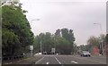
A54 approaching roundabout with the A5018
Image: © John Firth
Taken: 20 May 2014
0.12 miles
9

River Weaver Navigation at Winsford
The section of the river between the two bridges of the traffic island.
Image: © David Dixon
Taken: 9 May 2023
0.13 miles
10
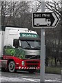
To the salt mine - Winsford - Cheshire
At the end of High Street, Winsford road signs direct traffic from the roundabout that crosses the River Weaver to the Meadowbank Mine on Bradford Road.
Image: © Andrew Fielding
Taken: 7 Jan 2009
0.13 miles