IMAGES TAKEN NEAR TO
Stocks Hill, WINSFORD, CW7 4EF
Introduction
This page details the photographs taken nearby to Stocks Hill, CW7 4EF by members of the Geograph project.
The Geograph project started in 2005 with the aim of publishing, organising and preserving representative images for every square kilometre of Great Britain, Ireland and the Isle of Man.

There are currently over 7.5m images from over14,400 individuals and you can help contribute to the project by visiting https://www.geograph.org.uk
Image Map
Images are licensed for reuse under creativecommons.org/licenses/by-sa/2.0
Notes
- Clicking on the map will re-center to the selected point.
- The higher the marker number, the further away the image location is from the centre of the postcode.
Image Listing (8 Images Found)
Images are licensed for reuse under creativecommons.org/licenses/by-sa/2.0
Image
Details
Distance
1
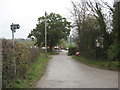
The end of the road --if you are driving
But walkers still have three options in Stocks Hill.
Image: © Dr Duncan Pepper
Taken: 13 Nov 2011
0.02 miles
5
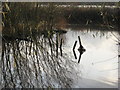
Sunken Fence Posts in Bottom Flash Lake
Image: © Dr Duncan Pepper
Taken: 12 Nov 2011
0.12 miles
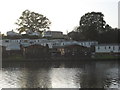
6
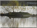
Artificial (?) duck island in Bottom Flash Lake
Image: © Dr Duncan Pepper
Taken: 12 Nov 2011
0.14 miles
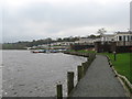
7
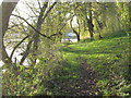
Willow fringed lakeside path at Bottom Flash
Image: © Dr Duncan Pepper
Taken: 12 Nov 2011
0.15 miles
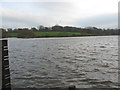
8
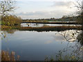
Bottom Flash Lake
Who thinks up these names?
Image: © Dr Duncan Pepper
Taken: 12 Nov 2011
0.18 miles