IMAGES TAKEN NEAR TO
Chapel Close, WINSFORD, CW7 4DT
Introduction
This page details the photographs taken nearby to Chapel Close, CW7 4DT by members of the Geograph project.
The Geograph project started in 2005 with the aim of publishing, organising and preserving representative images for every square kilometre of Great Britain, Ireland and the Isle of Man.

There are currently over 7.5m images from over14,400 individuals and you can help contribute to the project by visiting https://www.geograph.org.uk
Image Map
Images are licensed for reuse under creativecommons.org/licenses/by-sa/2.0
Notes
- Clicking on the map will re-center to the selected point.
- The higher the marker number, the further away the image location is from the centre of the postcode.
Image Listing (13 Images Found)
Images are licensed for reuse under creativecommons.org/licenses/by-sa/2.0
Image
Details
Distance
1

Elizabeth II postbox on Calveley Green Lane, Cholmondeston
Postbox No. CW7 182.
See Image] for context.
Image: © JThomas
Taken: 21 Mar 2024
0.03 miles
2
Calveley Green Lane, Cholmondeston
Showing position of Postbox No. CW7 182.
See Image] for postbox.
Image: © JThomas
Taken: 21 Mar 2024
0.03 miles
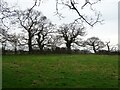
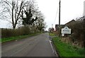
3
Calveley Green Lane
Cholmondeston end.
Image: © Richard Webb
Taken: 16 Jul 2019
0.05 miles
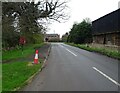
4
Cholmondeston
Winsford Road in Cholmondeston.
Image: © Peter McDermott
Taken: 4 Apr 2021
0.06 miles
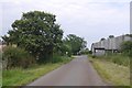
6
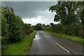
Winsford Road in Cholmondeston
The road is part of National Cycle Network route 551.
Image: © DS Pugh
Taken: 6 Aug 2023
0.07 miles
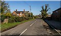
7
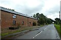
Road near Quercus House
The road is part of National Cycle Network route 551.
Image: © DS Pugh
Taken: 6 Aug 2023
0.09 miles
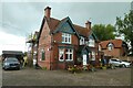
8
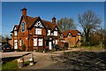
Little Man
Little Man public house in Wettenhall Green.
Image: © Peter McDermott
Taken: 4 Apr 2021
0.11 miles
9
Little Man Inn
A pub on Winsford Road in Cholmondeston.
Image: © DS Pugh
Taken: 6 Aug 2023
0.11 miles