IMAGES TAKEN NEAR TO
Winsford Road, WINSFORD, CW7 4DJ
Introduction
This page details the photographs taken nearby to Winsford Road, CW7 4DJ by members of the Geograph project.
The Geograph project started in 2005 with the aim of publishing, organising and preserving representative images for every square kilometre of Great Britain, Ireland and the Isle of Man.

There are currently over 7.5m images from over14,400 individuals and you can help contribute to the project by visiting https://www.geograph.org.uk
Image Map (Loading...)


Getting Data...Please wait
Leaflet Map data © OpenStreetMap
Images are licensed for reuse under creativecommons.org/licenses/by-sa/2.0
Notes
- Clicking on the map will re-center to the selected point.
- The higher the marker number, the further away the image location is from the centre of the postcode.
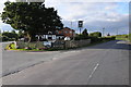
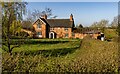
Image Listing (4 Images Found)
Images are licensed for reuse under creativecommons.org/licenses/by-sa/2.0
Image
Details
Distance
1
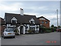
Boot and Slipper pub, Wettenhall
The Boot & Slipper stands at the junction of Winsford Road and Long Lane. Wettenhall doesn't have much of a village centre, being more a parish of scattered farms, but St. David's church is just down Long Lane - so I guess a pub plus a church = a community!
Image: © Mike Harris
Taken: 18 Jun 2006
0.13 miles
4
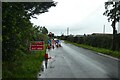
Temporary traffic lights on Winsford Road
The road is part of National Cycle Network route 551.
Image: © DS Pugh
Taken: 6 Aug 2023
0.24 miles