IMAGES TAKEN NEAR TO
Road Five, WINSFORD, CW7 3PG
Introduction
This page details the photographs taken nearby to Road Five, CW7 3PG by members of the Geograph project.
The Geograph project started in 2005 with the aim of publishing, organising and preserving representative images for every square kilometre of Great Britain, Ireland and the Isle of Man.

There are currently over 7.5m images from over14,400 individuals and you can help contribute to the project by visiting https://www.geograph.org.uk
Image Map
Images are licensed for reuse under creativecommons.org/licenses/by-sa/2.0
Notes
- Clicking on the map will re-center to the selected point.
- The higher the marker number, the further away the image location is from the centre of the postcode.
Image Listing (3 Images Found)
Images are licensed for reuse under creativecommons.org/licenses/by-sa/2.0
Image
Details
Distance
1
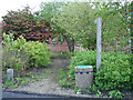
Escape route ... path leading out of Winsford Industrial Estate
Footpath leading out of Winsford Industrial Estate. 'Prettified' in 2000 under the Vale Royal Borough Council 'Changing Places' scheme. Unfortunately, like so many local authority projects, there seems to have been an initial capital budget but no provision for ongoing maintenance. The path is usually deep in litter. The litter bin is usually empty! The good news is that the path soon leads out of the industrial estate and into fields towards Stanthorne.
Image: © Mike Harris
Taken: 19 May 2007
0.05 miles
2
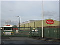
Henkel warehouse on Winsford Industrial Estate
Image: © Dr Duncan Pepper
Taken: 12 Nov 2011
0.10 miles
3
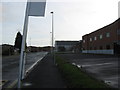
The end of the road- Road Five on Winsford Industrial Estate
Image: © Dr Duncan Pepper
Taken: 12 Nov 2011
0.17 miles