IMAGES TAKEN NEAR TO
Clive Lane, WINSFORD, CW7 3PA
Introduction
This page details the photographs taken nearby to Clive Lane, CW7 3PA by members of the Geograph project.
The Geograph project started in 2005 with the aim of publishing, organising and preserving representative images for every square kilometre of Great Britain, Ireland and the Isle of Man.

There are currently over 7.5m images from over14,400 individuals and you can help contribute to the project by visiting https://www.geograph.org.uk
Image Map
Images are licensed for reuse under creativecommons.org/licenses/by-sa/2.0
Notes
- Clicking on the map will re-center to the selected point.
- The higher the marker number, the further away the image location is from the centre of the postcode.
Image Listing (15 Images Found)
Images are licensed for reuse under creativecommons.org/licenses/by-sa/2.0
Image
Details
Distance
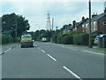
1
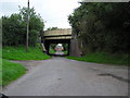
Start of Clive Back Lane
With the West Coast Mainline railway in the background.
Image: © DS Pugh
Taken: 6 Aug 2023
0.04 miles
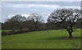
2
Clive Lane near Clive Hall Farm
The road forms part of National Cycle Network route 5.
Image: © DS Pugh
Taken: 6 Aug 2023
0.04 miles
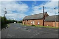
6
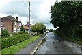
Rilshaw Lane approaching Clive Lane
The road forms part of National Cycle Network route 5.
Image: © DS Pugh
Taken: 6 Aug 2023
0.15 miles
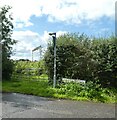
7
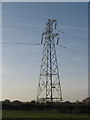
Pylon in farmland beside Clivegreen Road
Image: © Dr Duncan Pepper
Taken: 12 Nov 2011
0.18 miles
9
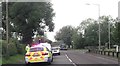
Clive Lane crossroads from Middlewich Road
No - he hadn't been pulled up - appears to have broken down
Image: © John Firth
Taken: 20 May 2014
0.19 miles