IMAGES TAKEN NEAR TO
Nat Lane Retail Park, Nat Lane, WINSFORD, CW7 3GZ
Introduction
This page details the photographs taken nearby to Nat Lane Retail Park, Nat Lane, CW7 3GZ by members of the Geograph project.
The Geograph project started in 2005 with the aim of publishing, organising and preserving representative images for every square kilometre of Great Britain, Ireland and the Isle of Man.

There are currently over 7.5m images from over14,400 individuals and you can help contribute to the project by visiting https://www.geograph.org.uk
Image Map
Images are licensed for reuse under creativecommons.org/licenses/by-sa/2.0
Notes
- Clicking on the map will re-center to the selected point.
- The higher the marker number, the further away the image location is from the centre of the postcode.
Image Listing (7 Images Found)
Images are licensed for reuse under creativecommons.org/licenses/by-sa/2.0
Image
Details
Distance
1
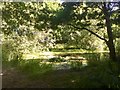
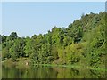
Parkland pond, Winsford
Former salt works land, now a wooded park
Image: © Richard Webb
Taken: 30 Jun 2018
0.08 miles
2
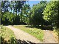
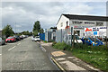
Paths, Weaver Parkway
Modern salt workings take up less room and surplus land has been landscaped into a wooded park and business areas including car showrooms.
Image: © Richard Webb
Taken: 30 Jun 2018
0.10 miles
3
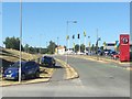
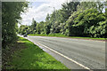
Weaver Valley Way
Car showroom on old salt mining land. Salt is still produced nearby, but less land is used nowadays.
Image: © Richard Webb
Taken: 30 Jun 2018
0.10 miles
7
Bench with a view of the River Weaver
On the wooded east bank, just south of Wharton.
Image: © Christine Johnstone
Taken: 14 Sep 2016
0.25 miles