IMAGES TAKEN NEAR TO
Fieldfare, WINSFORD, CW7 3EB
Introduction
This page details the photographs taken nearby to Fieldfare, CW7 3EB by members of the Geograph project.
The Geograph project started in 2005 with the aim of publishing, organising and preserving representative images for every square kilometre of Great Britain, Ireland and the Isle of Man.

There are currently over 7.5m images from over14,400 individuals and you can help contribute to the project by visiting https://www.geograph.org.uk
Image Map
Images are licensed for reuse under creativecommons.org/licenses/by-sa/2.0
Notes
- Clicking on the map will re-center to the selected point.
- The higher the marker number, the further away the image location is from the centre of the postcode.
Image Listing (14 Images Found)
Images are licensed for reuse under creativecommons.org/licenses/by-sa/2.0
Image
Details
Distance
1
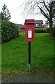
Elizabeth II postbox on Station Road, Winsford
Postbox No. CW7 210.
Image: © JThomas
Taken: 21 Mar 2024
0.09 miles
2
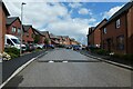
Proudman Way
Part of the housing development at Weaver Meadows.
Image: © DS Pugh
Taken: 6 Aug 2023
0.12 miles
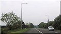
5
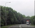
Winsford, Rilshaw Lane
The bridge crossing the A54 Winsford Bypass.
Image: © David Dixon
Taken: 9 May 2023
0.21 miles
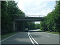
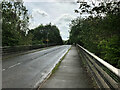
6
Bridge over Winsford Bypass
Looking along Rilshaw Lane from where part of National Cycle Network route 5 meets the road.
Image: © DS Pugh
Taken: 6 Aug 2023
0.21 miles
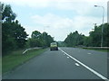
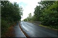
8
Rilshaw Lane near Weaver Meadows
The road forms part of National Cycle Network route 5.
Image: © DS Pugh
Taken: 6 Aug 2023
0.21 miles