IMAGES TAKEN NEAR TO
Grasmere Close, WINSFORD, CW7 2ST
Introduction
This page details the photographs taken nearby to Grasmere Close, CW7 2ST by members of the Geograph project.
The Geograph project started in 2005 with the aim of publishing, organising and preserving representative images for every square kilometre of Great Britain, Ireland and the Isle of Man.

There are currently over 7.5m images from over14,400 individuals and you can help contribute to the project by visiting https://www.geograph.org.uk
Image Map
Images are licensed for reuse under creativecommons.org/licenses/by-sa/2.0
Notes
- Clicking on the map will re-center to the selected point.
- The higher the marker number, the further away the image location is from the centre of the postcode.
Image Listing (6 Images Found)
Images are licensed for reuse under creativecommons.org/licenses/by-sa/2.0
Image
Details
Distance
1
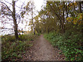
Whitegate Way parallel to Bradford Road
Image: © Stephen Craven
Taken: 18 Nov 2017
0.20 miles
2
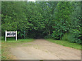
Whitegate Way, Winsford
This is the start/finish of the Whitegate Way, a permissive recreational route for walkers, horse riders and cyclists. It follows the line of an old salt-carrying railway line between Winsford and Cuddington (near Delamere Forest) that operated for almost one hundred years before closing in 1966. Here there is a car park off Bradford Road with a vandalized interpretation board. The sign to the left of shot marking the terminus appears to be one of the old station platform signs suitably annotated.
Image: © michael ely
Taken: 27 Jun 2006
0.20 miles
3
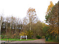
Eastern end of Whitegate Way
The route starts at the car park off Bradford Road Image
Image: © Stephen Craven
Taken: 18 Nov 2017
0.21 miles
4
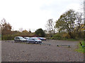
Car Park for the Whitegate Way
The car park is just off Bradford Road but is not well signed.
Image: © Stephen Craven
Taken: 18 Nov 2017
0.21 miles
5
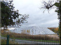
Covered salt stockpile, Bradford Road, Winsford (south end)
The weighted down sheeting covers a stockpile of rock salt about 170m long, up to 75m wide and maybe 15m high, making a volume of at least 150,000 cubic metres. There are other such stockpiles further down the Weaver valley. If you wonder whether there is demand for so much salt, see Andrew Fielding's photo Image
Image: © Stephen Craven
Taken: 18 Nov 2017
0.25 miles
6
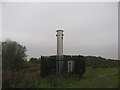
Former landfill site with (?) methane burner
Image: © Dr Duncan Pepper
Taken: 11 Nov 2011
0.25 miles