IMAGES TAKEN NEAR TO
Meadow Grove, WINSFORD, CW7 2PQ
Introduction
This page details the photographs taken nearby to Meadow Grove, CW7 2PQ by members of the Geograph project.
The Geograph project started in 2005 with the aim of publishing, organising and preserving representative images for every square kilometre of Great Britain, Ireland and the Isle of Man.

There are currently over 7.5m images from over14,400 individuals and you can help contribute to the project by visiting https://www.geograph.org.uk
Image Map
Images are licensed for reuse under creativecommons.org/licenses/by-sa/2.0
Notes
- Clicking on the map will re-center to the selected point.
- The higher the marker number, the further away the image location is from the centre of the postcode.
Image Listing (20 Images Found)
Images are licensed for reuse under creativecommons.org/licenses/by-sa/2.0
Image
Details
Distance
1
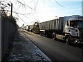
Lorries waiting to load with rock salt
Detail of lorries queueing to load with rock salt in Bradford Road, Winsford, Cheshire at the Salt Union mine.
Image: © Andrew Fielding
Taken: 6 Jan 2009
0.10 miles
2
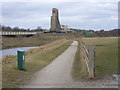
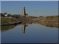
Salt Mine main shaft
Meadowbank Salt Mine from the footpath along the River Weaver
Image: © John Harrison
Taken: 25 Feb 2012
0.12 miles
3
Main shaft at salt mine in Winter
View across the Weaver.
Image: © John Harrison
Taken: 19 Jan 2013
0.12 miles
4

Meadowbank rock salt mine, Winsford
Over 100 lorries queue on Bradford Road to load with crushed rock salt during the coldest week in seven years, 6 January 2009, 10am. During these cold spells many hundreds of lorries arrive daily to load with rock salt to de-ice the country's roads. The site is operated by the Salt Union (Compass and Minerals), Winsford.
Image: © Andrew Fielding
Taken: 6 Jan 2009
0.12 miles
5
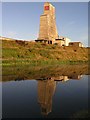
![Winsford Rock Salt Mine, from the River Weaver [1]](https://s0.geograph.org.uk/geophotos/05/16/42/5164212_c05704eb_120x120.jpg)
Winsford Rock Salt Mine, from the River Weaver [1]
Covered conveyor belts taking salt from the shaft to a tip site. This mine produces most of the salt used on Britain's winter roads. It was formerly called Meadowbank Mine.
Image: © Christine Johnstone
Taken: 14 Sep 2016
0.12 miles
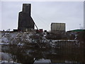
6
Winsford Rock Salt Mine
Winsford Rock Salt Mine is Britain’s oldest working mine http://www.winsfordrocksaltmine.co.uk/ it supplies a large percentage of the salt used for de-icing our roads. It is situated on the banks of the River Weaver.
Image: © Stephen Burton
Taken: 9 Jul 2014
0.12 miles
7
Salt works, by Weaver Navigation, Meadowbank near Winsford
Image: © Colin Park
Taken: 3 Feb 2015
0.13 miles
8
![Winsford Rock Salt Mine, from the River Weaver [5]](https://s2.geograph.org.uk/geophotos/05/16/50/5165046_98d99de5_120x120.jpg)
Winsford Rock Salt Mine, from the River Weaver [5]
The shaft where the salt is brought up. This mine produces most of the salt used on Britain's winter roads. It was formerly called Meadowbank Mine.
Image: © Christine Johnstone
Taken: 14 Sep 2016
0.13 miles
9
Meadowbank Mine
Britain's largest salt mine lies alongside the River Weaver at Winsford. This is the main skip winding shaft up which comes much of the winter salt for Britain's roads.
Image: © David Kitching
Taken: 2 Sep 2005
0.14 miles
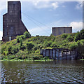
10
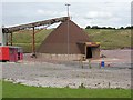
Salt dome, Meadowbank Mine
To stop the mined salt being blown across the district it is disgorged from the conveyors into this dome. From here it is taken by loading shovel to the stockpiles.
Image: © David Kitching
Taken: 1 Sep 2005
0.19 miles