IMAGES TAKEN NEAR TO
Bradford Road, WINSFORD, CW7 2PD
Introduction
This page details the photographs taken nearby to Bradford Road, CW7 2PD by members of the Geograph project.
The Geograph project started in 2005 with the aim of publishing, organising and preserving representative images for every square kilometre of Great Britain, Ireland and the Isle of Man.

There are currently over 7.5m images from over14,400 individuals and you can help contribute to the project by visiting https://www.geograph.org.uk
Image Map
Images are licensed for reuse under creativecommons.org/licenses/by-sa/2.0
Notes
- Clicking on the map will re-center to the selected point.
- The higher the marker number, the further away the image location is from the centre of the postcode.
Image Listing (30 Images Found)
Images are licensed for reuse under creativecommons.org/licenses/by-sa/2.0
Image
Details
Distance
1
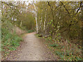
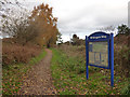
Whitegate Way looking north
At this point the path seems to deviate from the line of the railway route, but if you look at old maps it is probably more a case of moving from the line of industrial sidings onto the route of the "main" line (if you can apply that term to a single track freight branch).
Image: © Stephen Craven
Taken: 18 Nov 2017
0.05 miles
2
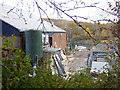
Excel Granite and Marble works, Winsford
Viewed from the adjacent Whitegate Way.
Image: © Stephen Craven
Taken: 18 Nov 2017
0.06 miles
3
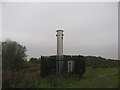
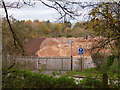
Former landfill site with (?) methane burner
Image: © Dr Duncan Pepper
Taken: 11 Nov 2011
0.09 miles
4
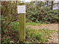
Warning sign for a landfill site
The sign reads "This is a former landfill site. Noxious and flammable substances are present on site. No unauthorised access. No smoking. Do not tamper with any equipment".
For a view of the site itself see Image
Image: © Stephen Craven
Taken: 18 Nov 2017
0.09 miles
5
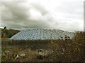
North end of salt stockpile
The weighted down sheeting covers a stockpile of rock salt about 170m long, up to 75m wide and maybe 15m high, making a volume of at least 150,000 cubic metres. There are other such stockpiles further down the Weaver valley. If you wonder whether there is demand for so much salt, see Andrew Fielding's photo Image
Image: © Stephen Craven
Taken: 18 Nov 2017
0.09 miles
6
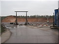
Entrance to Over Salt Works
Viewed from the adjacent Whitegate Way. Originally the mine was served by a siding from the railway that followed the line of this view, but now it generates entirely road traffic.
Image: © Stephen Craven
Taken: 18 Nov 2017
0.10 miles
7
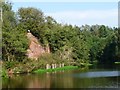
Overgrown brick retaining wall, Weaver Navigation
On the north bank, as the river twists eastwards. Too long to be a bridge abutment.
Image: © Christine Johnstone
Taken: 14 Sep 2016
0.13 miles
8
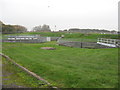
Winsford sewerage works
A green and peaceful spot!
Image: © Dr Duncan Pepper
Taken: 11 Nov 2011
0.14 miles
9
At first sight this looks like a sand quarry but given the location it's probably a salt storage depot
This is the (in)famous grit that we run out of every winter when it snows.
Image: © Dr Duncan Pepper
Taken: 11 Nov 2011
0.15 miles
10
Whitegate Way north of Wades Lane
See also Image
Image: © Stephen Craven
Taken: 18 Nov 2017
0.15 miles